Fjords: Nature's Sculptures - How Were They Carved?

The Glacial Genesis of Fjords
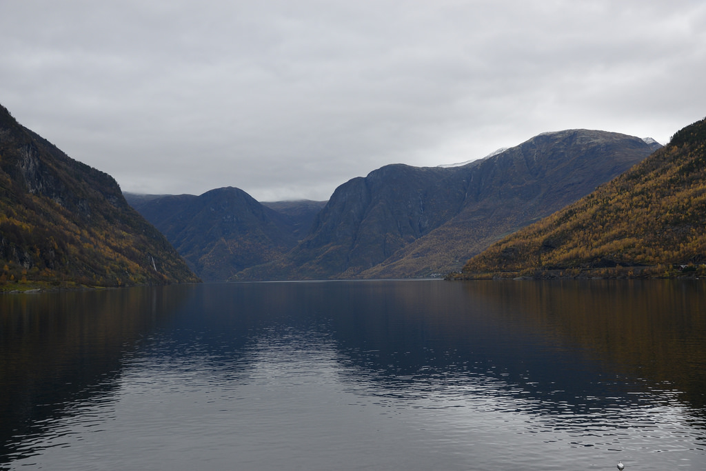
Fjords, those breathtaking inlets that punctuate dramatic coastal landscapes, are geological masterpieces sculpted over millennia primarily by the relentless force of glaciers. The story of a fjord begins during an ice age, when massive ice sheets advance from mountainous regions towards the sea. These aren't your typical glaciers; they are vast, thick rivers of ice, capable of carving deep valleys into the bedrock. This initial carving is the foundation upon which a fjord is built.
The process primarily involves glacial erosion. Unlike rivers, which primarily erode downwards, glaciers possess immense weight and a unique abrasive power. As they flow, they pluck rocks from the valley floor and walls through a process called quarrying or plucking. The ice also contains embedded rock debris, acting like sandpaper, grinding and smoothing the underlying bedrock. This combination of plucking and abrasion deepens and widens the valley, transforming it into a distinctive U-shaped valley, a key characteristic of a fjord. The immense pressure exerted by the ice also compacts and modifies the underlying rock structure, further contributing to the valley's shape and depth.
The sheer scale of this glacial activity is difficult to comprehend. Over countless years, repeated glacial advances and retreats deepen the valley far below the current sea level rise. This over-deepening is crucial, as it sets the stage for the fjord's eventual submersion. Furthermore, the weight of the ice sheet itself depresses the land. When the ice eventually melts, the land slowly rebounds, a process known as isostatic rebound, further influencing the final depth and configuration of the fjord. This process creates incredibly deep basins which are flooded later.
The Role of Glacial Valleys and U-Shaped Carving
The transformation of a typical river valley into a glacial valley is a dramatic one. Rivers, left to their own devices, typically carve V-shaped valleys. Glaciers, however, reshape these valleys into the characteristic U-shape. This is because the entire mass of the glacier is in contact with the valley floor and sides, eroding uniformly across the width of the valley. The result is a valley with steep, almost vertical walls and a flat bottom. This distinct U-shape is a telltale sign of past glacial activity and is a defining feature of fjords worldwide.
The depth of these U-shaped valleys is often staggering. Many fjords are hundreds, even thousands, of meters deep. This depth is a direct consequence of the intense glacial erosion that occurred over extended periods. The deepest fjords in the world are a testament to the immense power of ice to reshape the landscape. The Sognefjord in Norway fjords, for example, reaches depths exceeding 1,300 meters (4,265 feet). These depths create unique ecological environments and fascinating underwater landscapes.
Another important aspect is the presence of hanging valleys. These are smaller tributary valleys that join the main fjord valley high up on the sides. These hanging valleys were carved by smaller glaciers that flowed into the main glacier. When the ice melts, these valleys are left "hanging" above the main fjord, often creating spectacular waterfalls. These features add to the dramatic beauty of fjord geology.
Differentiating Glacial and River Valleys
Understanding the key differences between river and glacial valleys is crucial in recognizing the unique characteristics of fjords. River valleys typically exhibit a V-shaped profile due to the focused erosive power of the river channel. In contrast, glacial valleys are characterized by their U-shaped profile, wide bottoms, and steep sides, a result of the uniform erosion by the entire glacier mass.
The Significance of Hanging Valleys
Hanging valleys are a direct result of differential erosion rates. The main glacier, being much larger and more powerful, erodes its valley much more rapidly than the smaller glaciers in the tributary valleys. This difference in erosion rates leads to the creation of hanging valleys, adding to the scenic beauty of the fjord landscape with their waterfalls and elevated viewpoints.
The Role of Abrasion and Plucking
Glacial abrasion and plucking are the primary mechanisms behind the erosion of glacial valleys. Abrasion involves the grinding and smoothing of bedrock by rock debris embedded within the ice, while plucking involves the freezing of water into cracks in the bedrock and the subsequent removal of rock fragments as the glacier moves.
Sea Level Rise and Fjord Formation
The final stage in fjord formation involves sea level rise. As the ice age ends and temperatures rise, the glaciers melt, releasing vast amounts of water into the oceans. This causes a significant rise in sea level rise, which inundates the deeply carved glacial valleys, creating the fjords we see today. The submerged valleys become flooded with seawater, creating long, narrow inlets that extend far inland.
The depth of the submerged valleys is a key factor in determining the characteristics of the fjord. Deeper valleys result in longer and deeper fjords. The connection to the open ocean allows for tidal influences and the exchange of water masses, creating a unique and dynamic ecosystem. The steep sides of the fjord provide shelter from the open ocean, making them ideal harbors and havens for marine life.
It's important to note that the process of fjord formation is ongoing. Even today, the land is still rebounding from the weight of the ice sheets, slowly changing the shape and depth of the fjords. This isostatic rebound is a slow but continuous process that will continue to shape the coastal landscapes for thousands of years to come.
Fjord Geology and Unique Features
Fjord geology is complex and fascinating. The types of rock that underlie a fjord can significantly influence its shape and characteristics. For example, fjords carved in hard, resistant rock tend to be narrower and deeper than those carved in softer rock. The presence of faults and fractures in the bedrock can also influence the direction and shape of the fjord. The underlying fjord geology plays a crucial role in shaping the coastal landscapes.
One common feature of fjords is the presence of a "threshold" or sill at the mouth of the fjord. This is a shallow area that separates the deep inner basin of the fjord from the open ocean. This threshold can restrict water exchange and influence the salinity and oxygen levels within the fjord. These sills often create unique hydrological conditions. This restriction in the water exchange can also lead to anoxic conditions in the deeper layers of the water, especially if there is a large amount of organic matter input.
Furthermore, many fjords exhibit unique sedimentation patterns. Glacial sediments, such as silt and clay, are often deposited in the fjord, creating thick layers of sediment on the fjord floor. These sediments can provide valuable information about past glacial activity and environmental changes. Additionally, fjords act as sediment traps, accumulating organic matter and other pollutants, making them important archives of environmental change.
Analyzing Bedrock Composition
The geological composition of the bedrock surrounding a fjord plays a crucial role in its formation and characteristics. Fjords carved in harder rock types tend to be narrower and deeper, while those carved in softer rock types are typically wider and shallower. Understanding the bedrock composition helps in deciphering the fjord's evolutionary history and predicting its future response to environmental changes.
The Significance of Thresholds and Sills
Thresholds or sills at the mouth of fjords act as barriers to water exchange, influencing the salinity, oxygen levels, and nutrient distribution within the fjord. These sills create unique hydrological conditions and contribute to the formation of distinct ecological zones within the fjord ecosystem.

Sedimentation Processes in Fjords
Fjords act as sediment traps, accumulating glacial sediments, organic matter, and pollutants. The study of these sediments provides valuable insights into past glacial activity, environmental changes, and the impact of human activities on the fjord ecosystem. Analyzing sediment cores helps in reconstructing the fjord's history and understanding its response to environmental stressors.
The World's Most Famous Fjords
While fjords are found in various parts of the world, some are particularly renowned for their stunning beauty and geological significance. Norway fjords are perhaps the most famous, boasting iconic examples like the Sognefjord, Geirangerfjord, and Nærøyfjord. These fjords are known for their dramatic cliffs, cascading waterfalls, and picturesque villages nestled along their shores.
Beyond Norway, fjords are also found in Greenland, Chile, New Zealand, Canada, and Alaska. Each region offers unique fjord landscapes shaped by different geological conditions and climatic factors. For instance, the fjords of New Zealand are known for their lush rainforests and diverse wildlife, while the fjords of Greenland are characterized by their towering icebergs and remote wilderness.
| Fjord Name | Location | Maximum Depth (m) | Key Features |
|---|---|---|---|
| Sognefjord | Norway | 1308 | Longest and deepest fjord in Norway |
| Geirangerfjord | Norway | 260 | Famous for its waterfalls, including the Seven Sisters |
| Milford Sound | New Zealand | 291 | Known for its rainforests and wildlife |
| Scoresby Sund | Greenland | 1450 | One of the largest fjord systems in the world |
Exploring these magnificent coastal landscapes offers a glimpse into the powerful forces that have shaped our planet. From the glacial erosion of the ice age to the sea level rise that created the submerged valleys, the story of a fjord is a testament to the dynamic and ever-changing nature of Earth.
| Fjord Characteristic | Description | Contributing Factors |
|---|---|---|
| Depth | Can range from a few meters to over a kilometer deep. | Extent of glacial erosion, bedrock resistance, isostatic rebound. |
| Width | Typically narrow, but can vary depending on the surrounding topography. | Glacier size, bedrock composition, fault lines. |
| Presence of Threshold | A shallow area at the fjord mouth that restricts water exchange. | Glacial deposition, bedrock uplift. |
| Sedimentation Patterns | Thick layers of glacial sediments accumulate on the fjord floor. | Glacial meltwater, erosion of surrounding terrain. |
FAQ: Frequently Asked Questions About Fjord Formation
Here are some frequently asked questions about how fjords are formed:
Q: What is the primary force behind fjord formation?
A: The primary force behind fjord formation is glacial erosion during an ice age. The immense weight and abrasive power of glaciers carve deep, U-shaped valleys into the bedrock.
Q: How does sea level rise contribute to fjord formation?
A: As the ice age ends and glaciers melt, sea level rise inundates the deeply carved glacial valleys, creating the fjords we see today. The submerged valleys become filled with seawater.
Q: What are some key characteristics of a fjord?
A: Key characteristics of a fjord include its U-shaped valley, steep sides, great depth, and connection to the open ocean. The presence of a threshold or sill at the mouth is also common.
Q: Where are fjords typically found?
A: Fjords are found in high-latitude regions that were once covered by glaciers, such as Norway, Greenland, Chile, New Zealand, Canada, and Alaska. Norway fjords are especially well-known.
Q: How does fjord geology influence the characteristics of a fjord?
A: The types of rock that underlie a fjord can significantly influence its shape and depth. Fjords carved in hard rock tend to be narrower and deeper than those carved in softer rock.
Q: What are hanging valleys and how are they formed?
A: Hanging valleys are tributary valleys that join the main fjord valley high up on the sides. They are formed by smaller glaciers that flowed into the main glacier, eroding at a slower rate. When the ice melts, these valleys are left "hanging" above the main fjord, often creating waterfalls.
