100-Year Floodplain: Flood Risk, FEMA, and Insurance

Confused about the term "100-year floodplain" and what it means for your property and peace of mind? You're not alone. Many people struggle to understand this crucial concept. This comprehensive guide will break down everything you need to know, from its definition to its implications, ensuring you're well-informed and prepared.
What Exactly is a 100-Year Floodplain?
The term "100-year floodplain" can be misleading. It doesn't mean a flood will only occur once every 100 years. Instead, it refers to an area that has a 1% chance of experiencing a flood of a certain magnitude in any given year. Think of it as a statistical probability, not a guaranteed timeline. This area is also sometimes referred to as a flood zone with a 1% Annual Exceedance Probability (AEP).
More formally, the 100-year floodplain (also known as the 1% annual chance floodplain) is the area predicted to be inundated by the base flood. The base flood is a flood that has a 1% chance of being equaled or exceeded in any given year. This flood is the standard used by the National Flood Insurance Program (NFIP) for flood insurance and floodplain management purposes. It's important to note that floods exceeding the base flood (and thus inundating areas outside of the 100-year floodplain) can and do occur.
How are 100-Year Floodplains Determined?
Determining the boundaries of a 100-year floodplain is a complex process that involves detailed hydrological and hydraulic studies. Here's a breakdown of the key steps involved:
- Data Collection: This involves gathering historical data on rainfall, streamflow, topography, and other relevant factors. This data helps create a model of how water flows through the area.
- Hydrologic Analysis: This step uses the collected data to estimate the magnitude and frequency of floods in the area. Statistical methods are used to determine the flow rate of the base flood.
- Hydraulic Modeling: This involves using computer models to simulate how the base flood would flow through the floodplain. The models take into account the terrain, bridges, culverts, and other obstructions.
- Floodplain Mapping: Based on the results of the hydraulic modeling, FEMA flood maps are created that show the boundaries of the 100-year floodplain. These maps also depict the base flood elevation (BFE), which is the predicted height of the water during the base flood.
The Role of FEMA
The Federal Emergency Management Agency (FEMA) plays a crucial role in the identification and mapping of 100-year floodplains. FEMA works with state and local communities to develop and maintain FEMA flood maps, also known as Flood Insurance Rate Maps (FIRMs). These maps are used for a variety of purposes, including flood insurance rating, floodplain management, and community planning.
Technological Advancements in Flood Mapping
Advancements in technology, such as LiDAR (Light Detection and Ranging) and improved computer modeling techniques, have significantly improved the accuracy and precision of floodplain mapping. These technologies allow for more detailed and accurate assessments of flood risk, leading to better-informed decisions about flood mitigation and land use planning.
Understanding FEMA Flood Maps
FEMA flood maps, officially known as Flood Insurance Rate Maps (FIRMs), are essential tools for understanding flood risk. They provide a visual representation of flood zones, including the 100-year floodplain, and are used to determine flood insurance requirements and building regulations.
These maps are not static; they are updated periodically to reflect changes in topography, development, and hydrological conditions. Communities can request map revisions from FEMA based on new data or construction projects that may affect floodplain boundaries.
You can access FEMA flood maps through the FEMA website or your local government's planning department. Understanding how to read and interpret these maps is crucial for homeowners, developers, and anyone interested in flood risk assessment.
Implications of Living in a 100-Year Floodplain
Living in a 100-year floodplain has several significant implications, primarily related to flood insurance, building regulations, and property values.
- Flood Insurance Requirements: If your property is located within a 100-year floodplain and you have a mortgage from a federally regulated lender, you are typically required to purchase flood insurance. This is a key component of the NFIP.
- Building Regulations: Communities participating in the NFIP have adopted building regulations to minimize flood damage in flood zones. These regulations may include requirements for elevating structures, using flood-resistant materials, and restricting development in certain areas.
- Property Values: Properties located in flood zones may have lower property values compared to similar properties outside of these areas. This is due to the perceived risk of flooding and the associated costs of flood insurance and flood mitigation.

The Cost of Flood Insurance
The cost of flood insurance can vary depending on several factors, including the location of the property within the flood zone, the base flood elevation, and the type of construction. It's important to obtain quotes from multiple insurance providers to find the best coverage at the most affordable price. The National Flood Insurance Program (NFIP) is the primary source of flood insurance in the United States.
Mitigation Measures
Homeowners can take steps to reduce their flood risk and potentially lower their flood insurance premiums. These flood mitigation measures may include elevating the structure, installing flood vents, and improving drainage around the property. According to a 2024 study by the Association of State Floodplain Managers, investing in flood mitigation can significantly reduce long-term flood damage costs.
Floodplain Management and Mitigation Strategies
Effective floodplain management is essential for reducing the impacts of flooding on communities. This involves a combination of regulatory measures, engineering solutions, and community outreach efforts.
Floodplain management is not solely the responsibility of government agencies. Homeowners, developers, and community organizations all have a role to play in reducing flood risk. This includes making informed decisions about land use, implementing flood mitigation measures, and participating in community-level planning efforts.
Statistics show that communities with strong floodplain management programs experience significantly lower flood damage costs compared to those without such programs.
| Mitigation Strategy | Description | Benefits |
|---|---|---|
| Elevation | Raising a structure above the base flood elevation. | Reduces the risk of flood damage to the structure and its contents. |
| Floodproofing | Making a structure resistant to flood damage. | Protects the structure from floodwaters and minimizes potential losses. |
| Drainage Improvements | Improving drainage systems to reduce runoff and prevent flooding. | Reduces the volume and velocity of floodwaters, protecting properties from inundation. |
| Buyouts | Acquiring properties in high-risk flood zones and converting them to open space. | Removes structures from harm's way and creates space for floodwaters to spread out. |
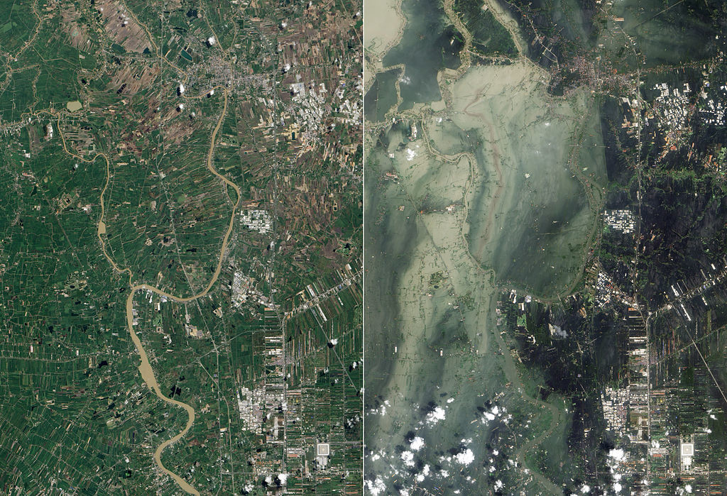
Coastal vs. Riverine Floodplains
It's important to distinguish between coastal flooding and riverine flooding, as the causes and characteristics of these types of floods can differ significantly.
Coastal flooding is typically caused by storm surges, high tides, and sea-level rise. These floods can be widespread and devastating, affecting large areas along the coast. The flood zones in coastal areas are often more complex and dynamic due to the influence of tides and waves.
Riverine flooding, on the other hand, is caused by excessive rainfall or snowmelt that overwhelms the capacity of rivers and streams. These floods tend to be more localized, affecting areas along the riverbanks and in the adjacent floodplain.
| Feature | Coastal Floodplain | Riverine Floodplain |
|---|---|---|
| Primary Cause | Storm surge, high tides, sea-level rise | Excessive rainfall, snowmelt |
| Extent | Widespread, affecting large coastal areas | Localized, affecting areas along rivers and streams |
| Duration | Can last for several days | Typically shorter duration, but can be prolonged |
| Key Factors | Tides, waves, coastal erosion | River flow, topography, drainage |
The Impact of Climate Change
Climate change is exacerbating both coastal flooding and riverine flooding. Rising sea levels are increasing the frequency and severity of coastal storm surges, while changes in precipitation patterns are leading to more intense rainfall events and increased riverine flood risk. Understanding these impacts is crucial for effective floodplain management and flood mitigation.
FAQ: Common Questions About 100-Year Floodplains
- Q: Does living in a 100-year floodplain mean my house will flood every 100 years?
- A: No. It means there's a 1% chance of a flood of a certain magnitude occurring in any given year.
- Q: How do I find out if my property is in a 100-year floodplain?
- A: You can check FEMA flood maps online or contact your local government's planning department.
- Q: What is the base flood elevation?
- A: The base flood elevation is the predicted height of the water during the base flood.
- Q: Is flood insurance required if I live in a 100-year floodplain?
- A: If you have a mortgage from a federally regulated lender, you are typically required to purchase flood insurance.
- Q: Can I appeal the designation of my property as being in a 100-year floodplain?
- A: Yes, you can request a Letter of Map Amendment (LOMA) from FEMA if you believe your property has been incorrectly designated.
Understanding the 100-year floodplain is vital for homeowners, developers, and community planners. By understanding the definition, how it's determined, and its implications, you can make informed decisions to protect your property and community from the devastating effects of flooding. Do you have questions about floodplains or flood insurance? Share your questions or experiences in the comments below!
