Tsunami Evacuation: Are Coastal Communities Prepared?
I remember visiting Seaside, Oregon, a few years ago. The vibrant energy of the boardwalk was infectious, the smell of saltwater taffy hung in the air, and the waves crashed rhythmically against the shore. But then I noticed it – a stark, blue sign with a white wave symbol and an arrow pointing inland. It wasn’t as prominent as the ice cream shops, but it was there, a silent reminder of the powerful forces that the Pacific could unleash: a tsunami. That simple sign underscored a critical reality: coastal communities need robust and well-understood evacuation plans to protect lives.
Understanding Tsunami Risk and Vulnerability
Before delving into evacuation routes, it's crucial to understand the inherent risks. Tsunami risk assessment involves analyzing various factors, including the geological history of the region, potential earthquake sources, and the topography of the coastline. Areas prone to coastal flooding and coastal erosion are inherently more vulnerable. According to a 2023 NOAA report, over 40% of the US population lives in coastal areas, highlighting the scale of potential impact. Furthermore, sea level rise exacerbates the threat, increasing the potential for inundation even from smaller tsunamis. Therefore, a comprehensive understanding of the specific vulnerabilities of a coastal community is the foundation for developing effective tsunami safety measures.
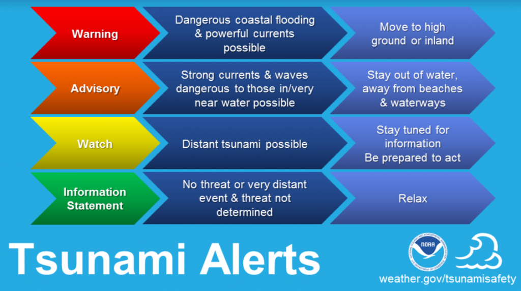
Furthermore, community awareness plays a pivotal role. Residents need to be informed about the signs of an impending tsunami, such as a strong earthquake, a sudden rise or fall in sea level, or a loud roar coming from the ocean, even if a formal tsunami warning hasn't been issued. Public education campaigns, drills, and accessible information resources are vital components of a comprehensive emergency preparedness strategy. Ignoring these signals can lead to delays in evacuation, significantly increasing the risk of injury or death.
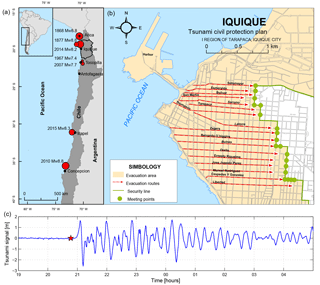
Mapping and Designing Effective Evacuation Routes
The creation of effective tsunami maps and evacuation routes is a multi-faceted process, demanding careful consideration of numerous factors. This isn't simply drawing a line from the beach to higher ground; it's about designing a system that accounts for population density, infrastructure limitations, and the potential for traffic congestion during an emergency.
Identifying Safe Zones and Assembly Points
The first step is pinpointing safe zones – areas located at a sufficient elevation and distance inland to be considered outside the potential inundation zone. These zones should be clearly marked on tsunami maps. Within these safe zones, designated assembly points need to be established. These assembly points should be easily accessible, have adequate space to accommodate evacuees, and ideally, have access to basic amenities like water and first aid supplies. Consideration should be given to accessibility for people with disabilities. Furthermore, alternative assembly points should be identified in case primary locations become inaccessible.
Optimizing Route Design and Signage
Designing the routes themselves involves analyzing existing road networks, identifying potential bottlenecks, and creating alternative routes to alleviate congestion. Routes should be as direct as possible, minimizing travel time to safe zones. Clear and unambiguous tsunami warning signs are essential, guiding evacuees along the designated paths. These signs should be strategically placed at regular intervals, especially at intersections and decision points. Signs should be visible day and night, and ideally, be made from durable, weather-resistant materials. Consideration should be given to multilingual signage in areas with diverse populations.
Accounting for Vulnerable Populations
A critical aspect of route design is accounting for vulnerable populations, including the elderly, people with disabilities, and those without access to private transportation. Special considerations may include designated evacuation assistance points, accessible transportation options, and the deployment of personnel to assist with evacuation. Furthermore, community outreach programs should be specifically tailored to these groups, ensuring they are aware of evacuation plans and have access to the resources they need.
Implementing and Maintaining Evacuation Routes
Designing the routes is just the first step; successful implementation and ongoing maintenance are equally crucial. This involves a coordinated effort between local government, disaster relief agencies, and the community.

Public Education and Drills
Regular public education campaigns are essential to raise awareness about tsunami safety and the importance of following evacuation plans. These campaigns should utilize various communication channels, including public service announcements, community meetings, and online resources. Furthermore, regular tsunami drills should be conducted to familiarize residents with the evacuation routes and procedures. These drills provide an opportunity to identify potential weaknesses in the evacuation plan and make necessary adjustments.
Maintaining Signage and Infrastructure
Ensuring that tsunami warning signs are well-maintained and clearly visible is paramount. Regular inspections should be conducted to identify and replace damaged or missing signs. Furthermore, the infrastructure along evacuation routes, such as roads and bridges, should be regularly inspected and maintained to ensure they are passable during an emergency. Obstructions, such as overgrown vegetation or debris, should be promptly removed.
Continuous Improvement and Adaptation
Tsunami risk assessment is an ongoing process. As new data becomes available and our understanding of tsunami hazards evolves, evacuation plans should be continuously reviewed and updated. This may involve adjusting evacuation routes, relocating assembly points, or implementing new communication strategies. Community feedback should be actively solicited and incorporated into the revision process. Furthermore, lessons learned from past events, both locally and globally, should be carefully analyzed and applied to improve emergency preparedness.
Resource Allocation and Funding
Effective tsunami preparedness demands dedicated resource allocation. Funding is needed for everything from risk assessments and route mapping to signage installation and public education programs. Local governments often rely on a combination of federal, state, and local funding sources to support these initiatives. Grant programs offered by agencies like FEMA (Federal Emergency Management Agency) can provide crucial financial assistance. However, securing these funds often requires a comprehensive tsunami mitigation plan and a demonstrated commitment to community safety. It is critical that communities prioritize tsunami preparedness and allocate sufficient resources to protect lives and property.
Table: Essential Components of a Tsunami Evacuation Plan
| Component | Description | Importance |
|---|---|---|
| Risk Assessment | Analysis of potential tsunami sources, inundation zones, and community vulnerability. | Foundation for effective planning. Identifies areas at highest risk. |
| Evacuation Routes | Clearly marked paths leading from inundation zones to safe areas. | Ensures efficient and safe movement of people during a tsunami. |
| Safe Zones/Assembly Points | Designated areas outside the inundation zone where evacuees can gather. | Provides a safe haven for evacuees and facilitates communication and assistance. |
| Warning System | Mechanism for disseminating tsunami warnings to the public (e.g., sirens, alerts). | Provides timely notification of an impending tsunami, allowing people to evacuate. |
| Public Education | Programs to raise awareness about tsunami hazards, evacuation procedures, and warning signs. | Empowers individuals to take proactive steps to protect themselves and their families. |
| Drills and Exercises | Regular simulations to test the effectiveness of the evacuation plan and familiarize residents with procedures. | Identifies weaknesses in the plan and improves community response. |
| Signage | Clearly visible and understandable directional signs along evacuation routes. | Guides evacuees to safety, especially those unfamiliar with the area. |
| Accessibility | Ensuring the plan is accessible to all community members, including those with disabilities. | Promotes equity and inclusivity in disaster preparedness. |
| Maintenance | Regular inspection and upkeep of signage, routes, and infrastructure. | Ensures the plan remains effective and reliable over time. |
Troubleshooting and Pro Tips
- Traffic Congestion: Plan multiple routes and designate lanes specifically for emergency vehicles. Consider implementing traffic control measures during evacuations.
- Communication Breakdown: Have backup communication systems in place, such as HAM radio operators, in case primary communication networks fail.
- Accessibility Issues: Designate accessible evacuation routes and transportation options for people with disabilities. Partner with community organizations to provide assistance.
- Power Outages: Ensure backup power is available for critical infrastructure, such as warning sirens and emergency shelters.
- False Alarms: While taking every warning seriously is essential, consider a clear protocol for communicating when a warning is canceled to prevent unnecessary disruption.
Pro Tip: Create a family emergency kit with essential supplies like water, food, first-aid supplies, a flashlight, and a battery-powered radio. Keep it readily accessible and practice using it regularly.
FAQ
- What is a tsunami evacuation route?
It's a pre-planned and clearly marked path designed to guide people from areas at risk of coastal flooding to safer, higher ground in the event of a tsunami. - How do I find my local tsunami evacuation route?
Contact your local emergency management agency or visit their website. Look for tsunami maps and evacuation plans. - What should I do if I am caught in a tsunami?
If possible, try to grab onto something that floats or climb to higher ground immediately. Stay away from the shoreline and be aware of strong currents and debris. - How can I prepare my family for a tsunami?
Develop an evacuation plan, assemble an emergency preparedness kit, and practice tsunami drills with your family. - What are the signs of a tsunami?
A strong earthquake, a sudden rise or fall in sea level, or a loud roar coming from the ocean can all be signs of a tsunami.
Protecting coastal communities from the devastating impact of tsunamis requires a proactive and multi-faceted approach. From understanding the underlying risks to meticulously designing and maintaining evacuation routes, every step is crucial. Don't wait for the next warning siren; take action today. Learn your local evacuation routes, assemble an emergency kit, and talk to your family about what to do in case of a tsunami. Share this information with your friends and neighbors. What questions do you still have about tsunami safety? Leave a comment below and let's start a conversation.
