Canadian Rockies Geology: Unearthing Ancient Secrets

I still remember the chill wind biting at my face as I stood on the shore of Lake Louise, gazing up at the towering, snow-capped peaks. It's a view that stops you in your tracks, a breathtaking panorama of raw, untamed beauty. But beyond the aesthetics, it's also a profound glimpse into deep time, a story etched in stone spanning hundreds of millions of years. The Canadian Rockies aren't just pretty; they're a geological marvel, a testament to the immense power of Earth's forces.
The Geological Setting of the Canadian Rockies
The Canadian Rockies form the eastern part of the Canadian Cordillera, a vast, complex mountain range that stretches from Alaska to the southern United States. Unlike the Appalachian Mountains, which formed much earlier, the Canadian Rockies are relatively young, geologically speaking, having been primarily shaped during the Laramide orogeny which took place during the Late Cretaceous and early Paleogene periods (roughly 80 to 55 million years ago). This period of intense mountain building resulted from the collision of tectonic plates, specifically the North American Plate and a series of terranes (crustal fragments) moving in from the west. The Rockies are composed predominantly of sedimentary rocks, unlike many other ranges that have cores of igneous or metamorphic rocks.
Formation of the Rocky Mountains: Tectonic Forces at Play
The formation of the Canadian Rockies is intimately linked to the movement and interaction of tectonic plates. During the Laramide orogeny, the relatively shallow angle of subduction of the Farallon Plate beneath the North American Plate resulted in a broad area of compression across western North America. This compression caused widespread folding and faulting of the sedimentary rocks that had accumulated in a shallow seaway called the Western Interior Seaway for hundreds of millions of years. The process wasn't a simple uplift; it involved the stacking and thrusting of huge sheets of rock eastward along major fault lines, a process known as thrust faulting. These thrust sheets, some kilometers thick, were essentially bulldozed over one another, creating the massive scale and complex structure we see today. The Lewis Thrust is one of the most significant.
Thrust Faulting and Fold Belts
Thrust faulting is the dominant structural feature of the Canadian Rockies. It involves the breakage and displacement of rock layers along low-angle faults, resulting in the overriding of one rock mass over another. This process creates a series of overlapping thrust sheets, each potentially containing different rock types and ages. The eastern margin of the Rockies is characterized by prominent fold belts, which are regions where the sedimentary rocks have been intensely folded due to the compressive forces.
The Role of Terranes
The accretion of terranes played a crucial role in the formation of the Canadian Cordillera, including the Rocky Mountains. Terranes are fragments of continental crust that have different geological histories and origins compared to the main continental mass. As these terranes collided with the western edge of North America, they added bulk and complexity to the crust, contributing to the overall uplift and deformation that shaped the mountain range.
Rock Types and the Geological Record
The rock formations of the Canadian Rockies tell a fascinating story of ancient environments and life. The vast majority of rocks are sedimentary rocks, ranging from shales and sandstones to limestones and dolomites. These rocks were deposited in a variety of marine and terrestrial environments over hundreds of millions of years, recording changes in sea level, climate, and life on Earth. The presence of fossil record further enriches the story of the Canadian Rockies.
Here's a table summarizing some common rock types found in the Canadian Rockies and their significance:
| Rock Type | Description | Significance |
|---|---|---|
| Limestone | A sedimentary rock composed primarily of calcium carbonate. | Often contains marine fossil record, indicating deposition in shallow seas. |
| Shale | A fine-grained sedimentary rock composed of clay minerals. | Can contain organic matter and be a source rock for hydrocarbons. |
| Sandstone | A sedimentary rock composed of sand-sized grains. | Indicates deposition in fluvial or nearshore environments. |
| Dolomite | A sedimentary rock similar to limestone, but with magnesium. | Often forms through alteration of limestone by magnesium-rich fluids. |
The Impact of Glaciation
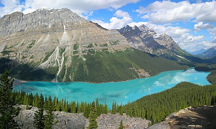
While the mountain building processes created the framework of the Canadian Rockies, glaciation has played a crucial role in sculpting the landscape into its present-day form. During the Pleistocene epoch (the last ice age), massive ice sheets covered much of North America, including the Canadian Rockies. These glaciers acted as powerful agents of erosion, carving out deep valleys, creating U-shaped valleys, cirques, and arêtes, and depositing vast amounts of sediment. Many of the iconic lakes in the Canadian Rockies, such as Lake Louise and Moraine Lake, are glacial in origin, formed by the scouring action of glaciers and the subsequent damming of valleys by glacial deposits. The glaciers also left behind numerous features like moraines.
**

Precambrian Rocks and the Foundation of the Rockies
Although the sedimentary rocks are more visible, Precambrian rocks also contribute to the geological story of the Canadian Rockies. These ancient rocks, some dating back billions of years, form the basement upon which the sedimentary rocks were deposited. In some areas, particularly in the westernmost parts of the Rockies and the Purcell Mountains, Precambrian rocks are exposed at the surface. These Precambrian rocks provide insights into the early history of the North American continent and the processes that shaped its crust. The Purcell Supergroup is an example of this Precambrian rocks.
Here's a simplified table to illustrate the major stages of the Rockies' geological history:
| Time Period | Key Events |
|---|---|
| Precambrian (4.5 billion - 541 million years ago) | Formation of the ancient continental crust; deposition of Precambrian rocks. |
| Paleozoic (541 - 252 million years ago) | Deposition of thick sequences of sedimentary rocks in a shallow sea. |
| Mesozoic (252 - 66 million years ago) | Continued deposition of sedimentary rocks; onset of the Laramide orogeny. |
| Cenozoic (66 million years ago - Present) | Peak of the Laramide orogeny; uplift and folding of the sedimentary rocks; glaciation and erosion. |
Modern Geological Processes
Geological processes continue to shape the Canadian Rockies today. Erosion by rivers, glaciers, and wind gradually wears down the mountains. Earthquakes are a reminder that the region is still tectonically active, although the frequency and magnitude of earthquakes are relatively low compared to other parts of the Canadian Cordillera. Climate change is also impacting the Rockies, with glaciers shrinking and permafrost thawing, leading to increased slope instability and potential for landslides. The ongoing process of mountain building will constantly reshape the Rockies.
**
The Effects of Erosion and Weathering
Erosion and weathering are key processes in constantly reshaping the Canadian Rockies. Water, wind, and ice continually break down rocks and transport sediment downhill, gradually reducing the height of the mountains and widening valleys. Freeze-thaw cycles, where water expands in cracks and fractures when it freezes, are particularly effective in breaking apart rocks at high elevations.
Seismic Activity and Fault Lines
While the Canadian Rockies are not as seismically active as other parts of the Canadian Cordillera, such as the coast of British Columbia, the region is still subject to earthquakes. These earthquakes are primarily caused by the ongoing tectonic stresses associated with the collision and interaction of tectonic plates. The presence of fault lines indicates zones of weakness in the Earth's crust where movement can occur, generating seismic waves. Many fault lines are ancient, but they can still be reactivated by modern stresses.
FAQ
Here are some frequently asked questions about the geology of the Canadian Rockies:
- Q: What are the Canadian Rockies made of?
- A: Primarily sedimentary rocks, such as limestone, shale, sandstone, and dolomite. There are also exposures of Precambrian rocks in some areas.
- Q: How were the Canadian Rockies formed?
- A: Primarily through the Laramide orogeny, which involved the collision of tectonic plates and the resulting folding and thrust faulting of sedimentary rocks.
- Q: How old are the Canadian Rockies?
- A: The sedimentary rocks that make up the Rockies range in age from Precambrian rocks to Mesozoic. The main phase of mountain building occurred during the Late Cretaceous and early Paleogene periods (around 80 to 55 million years ago).
- Q: What evidence of past life can be found in the Canadian Rockies?
- A: The sedimentary rocks contain a rich fossil record, including marine fossils, plant fossils, and trace fossils, providing insights into the ancient environments and organisms that existed in the region.
- Q: How has glaciation affected the Canadian Rockies?
- A: Glaciation has played a major role in sculpting the landscape, carving out deep valleys, creating lakes, and depositing vast amounts of sediment.
