The Modified Mercalli Intensity (MMI) Scale: How We Measure Earthquake Shaking & Damage
When an earthquake strikes, numbers fly across news reports. We hear about magnitude, depth, and location. But what about the actual experience of the earthquake? How did it feel? What kind of damage did it cause? That’s where the Modified Mercalli Intensity (MMI) Scale comes in. It's a qualitative measure, describing the effects of an earthquake on people, buildings, and the environment. It’s a crucial tool for understanding the true impact of these powerful events.
Understanding Earthquake Intensity
Earthquake intensity isn't just a number; it's a narrative. It's about understanding how the ground shook and what that shaking did. The Modified Mercalli Intensity Scale moves beyond simply measuring energy released (like the Richter scale) and instead focuses on the observable effects of an earthquake. This means considering everything from whether people felt it to the types of structural damage observed.
Unlike magnitude, which is a single value for an earthquake, intensity varies depending on your location. Closer to the epicenter, the shaking will generally be more intense. Further away, the shaking might be barely perceptible or not felt at all. This is why intensity is often mapped geographically, showing areas of different shaking levels. This mapping provides invaluable information to emergency responders and helps to assess the overall impact of the event. Understanding the MMI scale helps communities prepare for and recover from these natural disasters, taking into account local building practices and geological conditions.
The Modified Mercalli Scale: A Closer Look
The MMI scale uses Roman numerals, ranging from I (not felt) to XII (catastrophic destruction). Each level describes a range of effects. For instance, an intensity level of IV might mean that most people indoors felt the earthquake and some dishes rattled, while a level of VIII could mean considerable damage to poorly built structures, with even well-designed buildings experiencing some damage.
The scale is based on observations and reports from people who experienced the earthquake. These observations are then compiled and analyzed to determine the intensity level for different locations. This human element is what makes the MMI scale so valuable. It captures the nuances of how an earthquake affects people’s lives and their surroundings. The Mercalli Intensity Scale is also incredibly useful in areas where seismographs are sparse or unavailable, offering a way to understand earthquake effects based on observed damage and experiences.
Factors Influencing Intensity
The intensity of an earthquake isn't solely determined by its magnitude. Several factors can influence how strongly the ground shakes and the resulting damage. These factors include the depth of the earthquake, the type of soil, and the local geology.
For example, earthquakes that occur closer to the surface tend to produce stronger shaking than deeper earthquakes of the same magnitude. Similarly, soft soils can amplify shaking, leading to greater damage than would occur on solid bedrock. Building design and construction also play a critical role. Structures that are not earthquake-resistant are more vulnerable to damage, leading to higher intensity ratings. Therefore, understanding these factors is crucial for accurately assessing seismic risk and implementing appropriate mitigation measures. Analyzing these factors contribute to creating better seismic hazard maps that inform building codes and emergency planning.
Modified Mercalli Intensity Scale Levels
The MMI scale's distinct levels provide a structured way to categorize and understand the impact of an earthquake. Each level represents a different degree of shaking and associated effects. The descriptions are based on observed experiences and damage patterns.
These levels help paint a picture of the earthquake’s impact across different areas. For example, level VI indicates that everyone feels the earthquake, furniture moves, and some plaster cracks. Level IX, on the other hand, describes considerable damage even in specially designed structures, with ground cracks becoming visible. It is crucial to understand that these are guidelines, and the specific effects can vary depending on local conditions and building quality. The Modified Mercalli Scale aims to provide a consistent, standardized way to compare earthquake effects across different regions and time periods.
How Intensity is Measured and Mapped
The process of measuring and mapping intensity involves gathering data from a variety of sources. This includes reports from individuals who felt the earthquake, inspections of damaged buildings, and analyses of geological effects such as landslides or ground cracks.
Scientists use this information to create intensity maps, which show the geographical distribution of different intensity levels. These maps are valuable tools for emergency responders, urban planners, and engineers. They help identify areas that were most affected by the earthquake, assess the extent of the damage, and prioritize resources for recovery efforts. Furthermore, intensity maps can be used to improve seismic hazard assessments and inform building codes. The creation of these maps often involves sophisticated software and techniques to interpolate intensity values between observation points, providing a comprehensive picture of the earthquake's impact. These maps are critical for understanding the spatial variation of earthquake effects.
Using the MMI Scale for Hazard Assessment
The Modified Mercalli Intensity Scale is invaluable for assessing seismic hazards and informing risk reduction strategies. By analyzing historical earthquake data and correlating intensity levels with observed damage, scientists can identify areas that are particularly vulnerable to future earthquakes.
This information is crucial for developing building codes that require earthquake-resistant construction techniques, implementing land-use planning policies that avoid building in high-risk areas, and educating the public about earthquake safety. The scale helps communities understand the potential consequences of earthquakes and take steps to mitigate those risks. By combining intensity data with other geological and geophysical information, it is possible to create more accurate and comprehensive seismic hazard maps that inform policy decisions and protect lives and property. Using the Mercalli intensity scale for hazard assessment has improved community resilience to seismic events.
MMI vs. Magnitude: What's the Difference?
It's easy to confuse intensity and magnitude, as both describe earthquakes. However, they measure different things. Magnitude, like the Richter scale or moment magnitude scale, measures the energy released at the earthquake's source. It is a single value for a given earthquake, regardless of location. The earthquake magnitude provides information about the earthquake's size.
Intensity, on the other hand, measures the effects of the earthquake at a particular location. It varies depending on distance from the epicenter, soil conditions, and building construction. A single earthquake will have one magnitude but many intensity values. Magnitude describes the earthquake's power, while intensity describes its impact. Understanding the difference between these two measures is essential for effectively communicating earthquake risk and planning for disaster response. The intensity of an earthquake can tell us more about how the population experienced the shaking.
Limitations of the MMI Scale
While the Modified Mercalli Intensity Scale is a valuable tool, it's important to acknowledge its limitations. Because it relies on subjective observations, intensity assessments can vary depending on the observer. Additionally, the scale may not be as accurate in areas with sparse populations or limited infrastructure. For instance, in a remote area with few buildings, it can be difficult to assess the intensity of shaking based on structural damage.
Furthermore, the scale's reliance on human observations makes it challenging to apply consistently across different regions and time periods. Building codes and construction practices vary widely, which can affect the level of damage associated with a given intensity level. Despite these limitations, the MMI scale remains a useful tool for understanding the impact of earthquakes, particularly when combined with other data sources such as seismographic recordings and geological surveys. Efforts are continually underway to refine and improve the scale, addressing its inherent subjectivity and incorporating new scientific knowledge. The reliance on macroseismic observations is both a strength and a weakness of the Modified Mercalli scale.
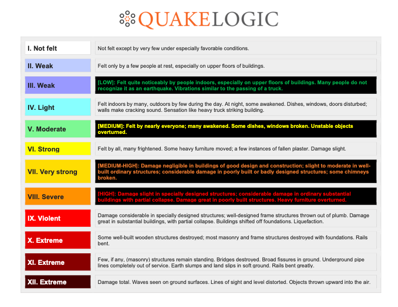
| Intensity Level | Description of Effects |
|---|---|
| I | Not felt except by a very few under especially favorable conditions. |
| II | Felt only by a few persons at rest, especially on upper floors of buildings. |
| III | Felt quite noticeably by persons indoors, especially on upper floors of buildings. Many people do not recognize it as an earthquake. Standing motor cars may rock slightly. Vibrations similar to the passing of a truck. Duration estimated. |
| IV | Felt indoors by many, outdoors by few during the day. Dishes, windows, doors disturbed; walls make cracking sound. Sensation like heavy truck striking building. Standing motor cars rocked noticeably. |
| V | Felt by nearly everyone; many awakened. Some dishes, windows, etc., broken; a few instances of cracked plaster; unstable objects overturned. Disturbance of trees, poles and other tall objects sometimes noticed. Pendulum clocks may stop. |
| VI | Felt by all, many frightened. Some heavy furniture moved; a few instances of fallen plaster or damaged chimneys. Damage slight. |
| VII | Damage negligible in buildings of good design and construction; slight to moderate in well-built ordinary structures; considerable damage in poorly built or badly designed structures; some chimneys broken. |
| VIII | Damage slight in specially designed structures; considerable damage in ordinary substantial buildings with partial collapse; great damage in poorly built or badly designed structures. Panel walls thrown out of frame structures. Fall of chimneys, factory stacks, columns, monuments, walls. Heavy furniture overturned. Sand and mud ejected in small amounts. Changes in well water. Disturbs persons driving motor cars. |
| IX | Damage considerable in specially designed structures; well-designed frame structures thrown out of plumb; great damage in substantial buildings, with partial collapse. Buildings shifted off foundations. Ground cracked conspicuously. Underground pipes broken. |
| X | Some well-built wooden structures destroyed; most masonry and frame structures destroyed with foundations; ground badly cracked. Rails bent. Landslides considerable from river banks and steep slopes. Shifted sand and mud. Water splashed (slopped) over banks. |
| XI | Few, if any (masonry) structures remain standing. Bridges destroyed. Broad fissures in ground. Underground pipelines completely out of service. Earth slumps and land slips in soft ground. Rails bent greatly. |
| XII | Damage total. Waves seen on ground surface. Lines of sight and level are distorted. Objects thrown upward into the air. |
Advancements in Intensity Assessment
Modern technology is bringing new advancements to intensity assessment. "Shake Map" technology, for example, uses data from seismic networks to automatically generate maps showing the distribution of shaking intensity shortly after an earthquake. These maps provide valuable information for emergency response and damage assessment. Shake Map technology helps to visualize the spatial distribution of shaking.
Furthermore, researchers are exploring the use of social media data to gather information about earthquake effects. By analyzing tweets and other online posts, it may be possible to quickly assess the intensity of shaking in different areas. These new approaches promise to improve the accuracy and timeliness of intensity assessments, ultimately leading to better preparedness and response to earthquakes. Using both traditional and new techniques leads to a better understanding of the intensity data.
The Future of Intensity Scales
The future of intensity scales likely involves a combination of traditional methods and advanced technologies. As seismic networks become denser and more sophisticated, we can expect to see more accurate and detailed intensity maps. Social media and citizen science initiatives can also play a larger role in gathering real-time information about earthquake effects. The crowdsourced intensity data will continue to improve the precision of intensity mapping.
Furthermore, research is ongoing to develop more sophisticated intensity scales that take into account a wider range of factors, such as soil conditions, building types, and the vulnerability of different populations. These advances will help us better understand the impact of earthquakes and develop more effective strategies for mitigating their risks. Continual advancements in seismology and data analysis will bring the Modified Mercalli Intensity Scale into the future.
Frequently Asked Questions (FAQ)
Here are some frequently asked questions about the Modified Mercalli Intensity Scale:
Q: What does an intensity of VII mean?
A: An intensity of VII on the Modified Mercalli Scale indicates that damage is negligible in buildings of good design and construction, slight to moderate in well-built ordinary structures, considerable damage in poorly built or badly designed structures, and some chimneys are broken.
Q: How does the MMI scale help after an earthquake?
A: The MMI scale helps emergency responders assess the extent of damage and prioritize resources for recovery efforts. Intensity maps show the geographical distribution of different intensity levels, allowing responders to focus on the areas most affected by the earthquake.
Q: Is the MMI scale subjective?
A: Yes, the MMI scale relies on subjective observations of earthquake effects, which can vary depending on the observer. However, efforts are made to standardize the assessment process and combine observations from multiple sources to improve accuracy.
Q: Can the MMI scale be used for historical earthquakes?
A: Yes, the MMI scale can be used to estimate the intensity of historical earthquakes based on written accounts and other historical records. This information is valuable for understanding long-term seismic hazards and assessing the vulnerability of different regions.
In conclusion, the Modified Mercalli Intensity Scale provides a valuable perspective on the impacts of earthquakes. By focusing on observed effects rather than simply measuring energy release, it helps us understand how earthquakes affect people, buildings, and the environment. While the MMI scale has limitations, ongoing advancements in technology and data analysis are improving its accuracy and usefulness. As we continue to learn more about earthquakes, intensity scales will remain an essential tool for assessing seismic hazards and mitigating risks, contributing to safer and more resilient communities in the face of these powerful natural events.
