Elevating Earth: The Ultimate Guide to Mountain Formation Through the Rock Cycle, Plate Tectonics, and Orogeny
Imagine standing at the foot of a towering mountain range, gazing upward at peaks that pierce the sky. Have you ever wondered how these majestic formations came to be? The story of mountain formation is a fascinating tale intricately woven with the rock cycle, the relentless dance of plate tectonics, and the powerful process of orogeny. It's a story of immense forces, geological time scales, and the continuous reshaping of our planet, a captivating journey of Elevating Earth.
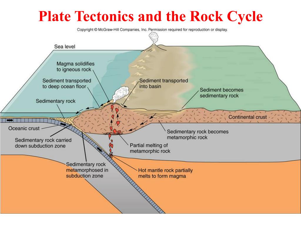
The Rock Cycle: Foundation of the Mountains
The rock cycle is the engine that drives the creation and destruction of all rocks on Earth, including those that make up mountains. It's a continuous process where rocks are constantly being formed, broken down, and transformed from one type to another. Understanding this cycle is crucial to grasping how mountains are born. Igneous rocks, formed from cooled magma or lava, can be uplifted and exposed at the surface. Sedimentary rocks, composed of accumulated sediments like sand and mud, can be buried and compressed. Metamorphic rocks, transformed by intense heat and pressure, also play a key role in mountain building.
Think of the rock cycle as a geological conveyor belt. Magma cools to form igneous rock, which then weathers and erodes into sediment. This sediment compacts to form sedimentary rock, which can then be subjected to intense heat and pressure to become metamorphic rock. And these rocks can all be involved in orogeny, adding to the complexity of mountain formations. This cycle ensures that the raw materials for mountain building are constantly being replenished and reshaped. The weathering and erosion process is also a key element when looking at mountain degradation.
Plate Tectonics: The Driving Force
Plate tectonics provides the mechanism behind mountain formation. The Earth's lithosphere is divided into several large and small plates that are constantly moving. These plates interact at their boundaries in various ways, and it's at these boundaries where most mountain building occurs. The immense forces generated by these interactions are responsible for the uplift, folding, and faulting of rocks that lead to the creation of mountains. This is a key part of understanding global mountain ranges.
There are three primary types of plate boundaries: convergent, divergent, and transform. At convergent boundaries, plates collide, and it's here where some of the most dramatic mountain ranges are formed. At divergent boundaries, plates move apart, creating mid-ocean ridges and rift valleys. While not directly involved in mountain building like convergent boundaries, they contribute to the overall tectonic activity of the Earth. Transform boundaries, where plates slide past each other horizontally, can also cause localized uplift and deformation. The theory of plate tectonics gives scientists the best way to understand the process of mountain formation.
Orogeny: The Mountain-Building Process
Orogeny is the term used to describe the process of mountain building. It encompasses all the geological events that lead to the formation of mountains, including folding, faulting, uplift, and metamorphism. Orogeny is not a single, instantaneous event but rather a long and complex process that can take millions of years. It's a dynamic interplay of forces that sculpt the Earth's surface and create the magnificent mountain ranges we see today. The effects of orogeny are long-lasting and impactful.
Orogeny often occurs at convergent plate boundaries where two continental plates collide. The immense pressure causes the crust to buckle and fold, resulting in the uplift of mountain ranges. The Himalayas, for example, were formed by the collision of the Indian and Eurasian plates. Orogeny can also occur at subduction zones, where one plate slides beneath another. The Andes Mountains were formed as the Nazca Plate subducted beneath the South American Plate. This process shows how specific geographical areas are formed by orogeny.
Folding and Faulting: Deforming the Crust
Folding and faulting are two primary ways in which the Earth's crust deforms under stress, playing crucial roles in the architecture of mountain ranges. Folding occurs when rocks are compressed and bend into wavelike structures, while faulting involves the fracturing and displacement of rock along a fault line. These processes often work in tandem during orogeny, creating complex and varied landscapes. The ability of rocks to fold or fault depends on factors such as their composition, temperature, and the rate at which stress is applied.
Folds can be classified as anticlines (upward folds) and synclines (downward folds). Large-scale folding can result in the formation of entire mountain ranges. Faults are fractures in the Earth's crust where movement has occurred. There are several types of faults, including normal faults, reverse faults, and strike-slip faults. Faulting can cause significant uplift and displacement, creating steep cliffs and valleys. The combination of folding and faulting contributes to the rugged terrain that characterizes many mountain ranges. Understanding these geological processes is fundamental to the study of structural geology.
Volcanism and Mountain Formation
Volcanism, the eruption of molten rock onto the Earth's surface, is intimately linked to mountain formation. Volcanic mountains are formed when magma erupts and cools, building up layers of lava and ash over time. These mountains often have a conical shape with a central vent from which eruptions occur. Volcanism is particularly common at subduction zones and rift valleys, where magma is generated by the melting of the mantle. These formations add to the diversity of landscapes.
The type of eruption and the composition of the lava can vary greatly, leading to different types of volcanic mountains. Shield volcanoes, like those in Hawaii, are formed by effusive eruptions of fluid basaltic lava. Stratovolcanoes, like Mount Fuji, are formed by alternating layers of lava and ash from explosive eruptions. Volcanic activity can also contribute to the uplift of existing mountains, adding to their height and complexity. The Ring of Fire is a great example of how volcanism contributes to mountain formations.
Erosion and Weathering: Shaping the Peaks
While tectonic forces build mountains, erosion and weathering act as relentless sculptors, shaping the peaks and valleys over vast stretches of time. Erosion is the process by which rocks and soil are worn away and transported by agents such as water, wind, and ice. Weathering is the breakdown of rocks and minerals at the Earth's surface through physical and chemical processes. These processes are crucial in defining the final appearance of mountain ranges. This process also helps create and change different soil types.
Glaciers are particularly effective agents of erosion in mountainous regions. As glaciers move, they carve out U-shaped valleys and erode away the surrounding rock. Water erosion, through rivers and streams, also plays a significant role in shaping mountain landscapes. Wind erosion can be particularly effective in arid regions, where it can sculpt rock formations into unusual shapes. The balance between uplift and erosion determines the overall height and shape of a mountain range. The Grand Canyon is a great example of the power of erosion.
The Role of Isostasy
Isostasy is the principle of gravitational equilibrium between the Earth's crust and mantle. It explains why mountains stand so high above the surrounding terrain and how the crust responds to changes in mass. The Earth's crust "floats" on the denser mantle, and the height to which it floats depends on its thickness and density. Mountains, being thick and relatively lightweight, extend deep into the mantle, like an iceberg floating in water. Understanding isostasy helps explain why mountain ranges can exist for millions of years.
When mountains are eroded, the crust becomes lighter, and the principle of isostasy dictates that it will rebound upward. This process, known as isostatic rebound, can cause the land to rise even after the forces that created the mountains have ceased to operate. The ongoing isostatic rebound in Scandinavia, caused by the melting of ice sheets after the last Ice Age, is a clear example of this phenomenon. This principle can also explain changes in sea level due to glacial formations.
Mountain Belts and Their Formation
| Mountain Belt | Formation Mechanism | Location |
|---|---|---|
| Himalayas | Collision of Indian and Eurasian plates | Asia |
| Andes | Subduction of Nazca Plate beneath South American Plate | South America |
| Appalachians | Ancient collision of North American and African plates | North America |
| Alps | Collision of African and European plates | Europe |
Mountain belts are extensive linear regions of mountain ranges that are often formed by similar tectonic processes over long periods. These belts represent zones of intense crustal deformation and are characterized by complex geological structures. Understanding the formation of mountain belts is key to understanding the large-scale tectonics of our planet.
The formation of mountain belts often involves multiple stages, including initial rifting, followed by ocean basin formation, and finally, convergence and collision. The Appalachian Mountains, for example, were formed by a series of collisions between North America, Africa, and Europe hundreds of millions of years ago. The study of mountain belts provides valuable insights into the history of plate tectonics and the evolution of the Earth's continents. Mountain ranges are a key element of the geological record.
Dating Mountain Formation
| Dating Method | Principle | Applications |
|---|---|---|
| Radiometric Dating | Measuring the decay of radioactive isotopes | Determining the age of rocks and minerals |
| Fission Track Dating | Counting the tracks left by the spontaneous fission of uranium | Determining the age of volcanic rocks and minerals |
| Cosmogenic Nuclide Dating | Measuring the concentration of rare isotopes produced by cosmic rays | Determining the age of exposed rock surfaces |
| Thermochronology | Analyzing the thermal history of rocks | Determining the timing of uplift and erosion |
Determining the age of mountains is a complex but crucial endeavor for understanding Earth's geological history. Scientists employ various dating methods to unravel the timelines of mountain formation, uplift, and erosion. These methods rely on different principles and are applicable to different types of rocks and minerals.
Radiometric dating, such as uranium-lead dating and potassium-argon dating, is commonly used to determine the age of igneous and metamorphic rocks. Fission track dating is useful for dating volcanic rocks and minerals. Cosmogenic nuclide dating is used to determine the age of exposed rock surfaces, providing insights into erosion rates. Thermochronology helps reconstruct the thermal history of rocks, allowing scientists to determine when they were uplifted and cooled. These dating methods, combined with geological mapping and structural analysis, provide a comprehensive understanding of mountain formation timelines.
FAQ: Elevating Earth
Here are some frequently asked questions about mountain formation:
Q: What is the difference between a mountain and a hill?
A: While there's no universally agreed-upon definition, mountains are generally taller and steeper than hills. They often have a distinct peak and a significant local relief. The United Nations defines a mountain as having a local relief of 300 meters or more from the surrounding terrain.
Q: Can mountains grow taller over time?
A: Yes, mountains can continue to grow taller if the forces causing uplift exceed the rate of erosion. The Himalayas, for example, are still rising due to the ongoing collision of the Indian and Eurasian plates.
Q: Are all mountains formed by plate tectonics?
A: While plate tectonics is the primary driving force behind mountain formation, some mountains are formed by other processes, such as volcanism or erosion of plateau surfaces.
Q: What is the oldest mountain range on Earth?
A: Determining the absolute oldest mountain range is difficult, as erosion and geological processes can obscure their origins. However, some of the oldest known mountain ranges include the Barberton Greenstone Belt in South Africa and the Pilbara Craton in Western Australia, dating back billions of years.
Conclusion: A Dynamic Earth
The story of mountain formation is a testament to the dynamic nature of our planet. From the relentless cycling of rocks to the powerful forces of plate tectonics and orogeny, mountains are constantly being created, shaped, and destroyed. Understanding these processes provides valuable insights into the history of the Earth and the forces that continue to shape our world. As we continue to explore and study these majestic formations, we gain a deeper appreciation for the complex and interconnected systems that make our planet so unique. Future research into the use of AI and improved monitoring may give a better understanding of mountain erosion and formation to ensure sustainability.
