Mastering spits, bars, tombolos, coastal landforms Effectively
Unveiling the Mysteries of Spits, Bars, and Tombolos: Dynamic Coastal Landforms
Our planet's coastlines are ever-changing landscapes, constantly sculpted by the powerful forces of nature. From the persistent rhythm of ocean waves to the subtle influence of wind, every element contributes to shaping diverse and often breathtaking features. Among the most intriguing and vital formations are spits, bars, and tombolos. These remarkable coastal landforms are not static geographical features; they are dynamic indicators of the intricate interplay between land, sea, and sediment. Understanding how these spits, bars, and tombolos form, interact, and evolve is crucial for comprehending coastal geomorphology and preparing for a future increasingly susceptible to climatic shifts. This article invites you to delve deeply into the world of spits, bars, and tombolos, offering a comprehensive and clear understanding of these magnificent natural phenomena.
Quick Answer: Spits are elongated sediment deposits extending from the coastline into the sea, primarily formed by longshore drift. Bars are linear sediment accumulations, either submerged or exposed, running parallel to the coast and acting as natural barriers. Tombolos are distinctive sediment bridges that connect an island or a stack to the mainland, often resulting from the merging of spits or bars. All three are profound examples of coastal deposition, where the dynamic forces of waves and currents transport and deposit sediment, playing crucial roles in both coastal ecosystems and shoreline protection. These fascinating coastal landforms are essential to understand.
Deciphering Coastal Landforms: Spits, Bars, and Tombolos
The geomorphology of coastal areas is a testament to constant change, shaping unique and captivating features. Spits, bars, and tombolos represent three of the most frequently encountered coastal landforms on sandy shorelines across the globe. Each possesses distinct characteristics, formation processes, and ecological significance, yet all stand as undeniable evidence of the ocean's transformative power. To truly grasp the pulse of our planet, we must first learn to interpret the messages etched into these coastal landforms.
What are Spits? Definition and Key Characteristics of this Coastal Landform
A spit is a coastal landform created when sediment, such as sand or shingle, is transported along the shoreline—a process known as longshore drift—and then deposited at a point where the coastline abruptly changes direction, or at the mouth of an estuary or bay. The result is an elongated "tongue" of land projecting outwards into the sea or across a bay. The seaward end of a spit often curves inwards towards the land, forming a distinctive 'hook' or 'recurved tip'. This curvature is typically caused by wave refraction around the exposed tip, or by the influence of tidal currents and secondary wave fronts from the opposite direction. Spits can vary significantly in size, ranging from a few tens of meters to many kilometers in length. They are not merely static piles of sand; they are dynamic entities, constantly reshaped by wave action and currents, often creating sheltered lagoon formations or salt marshes on their landward side, providing vital habitats for various salt-tolerant plant and bird species. These dynamic coastal landforms are crucial for understanding shoreline development.
Understanding Bars: Types and Formation Processes of these Coastal Features
The term 'bar' within the context of coastal geomorphology refers to a linear accumulation of sediment that generally runs parallel to the coastline. Bars can manifest in several forms: they can be submerged bars (also known as offshore bars or sandbars) which lie underwater and are only visible during exceptionally low tides or not at all; or they can rise above sea level, forming barrier islands or baymouth bars. The formation of bars is intricately linked to wave action and sediment transport. Waves breaking offshore or in shallower waters often lose energy, causing them to deposit the sediment they carry. Over time, this deposition builds up into a ridge parallel to the shore. Barrier islands, a specific type of bar, often form in response to rising sea levels, where coastal ridges become separated from the mainland. Baymouth bars, on the other hand, are similar to spits but extend completely across a bay, effectively sealing it off from the open ocean and creating a lagoon or estuary behind them. These natural barriers serve as significant protective features against coastal erosion and storm surges, shielding the mainland and its ecosystems. Bars are therefore critical coastal landforms.
Tombolos: Nature's Bridges Between Land and Island
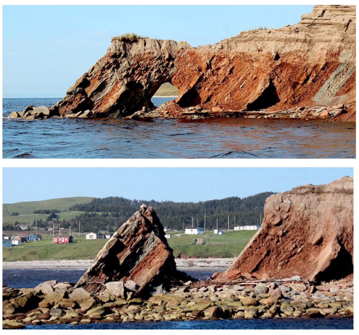
A tombolo is a unique type of coastal landform created when a spit or a bar connects an island or a sea stack to the mainland. The word 'tombolo' originates from Italian, meaning 'mound' or 'hillock'. The formation of a tombolo typically occurs in areas where longshore drift is interrupted by the presence of an island. As waves approach the island, they undergo wave refraction, bending around its sides. This causes wave energy to dissipate in the sheltered zone directly behind the island, leading to the deposition of sediment. Gradually, this accumulated sediment builds up, forming a strip of land that 'bridges' the island to the main coastline. Tombolos can be permanent features or only appear at certain tidal conditions. They are often significant tourist attractions and vital ecological sites, creating unique micro-environments with differing tidal currents and wave energies on either side of the sediment bridge. Sometimes, two opposing spits can grow and meet behind an island, forming a double tombolo, further illustrating the intricate dynamics of marine processes. These distinctive coastal landforms highlight the diversity of our shorelines.
Geological Mechanisms Behind Coastal Formations
The genesis of spits, bars, and tombolos is the culmination of complex geological processes, powered by the relentless dynamics of waves, currents, and the continuous supply of sediment. Understanding these fundamental mechanisms is not merely an academic exercise; it is crucial for accurately predicting future coastline changes, managing precious coastal resources, and truly comprehending the profound influence the ocean has on shaping the land.
The Pivotal Role of Waves and Coastal Currents in Shaping Spits, Bars, and Tombolos
Waves, predominantly generated by wind passing over the sea surface, are the principal agents responsible for the movement of sediment within the coastal zone. As waves approach the shore, they begin to interact with the seabed, causing them to refract, or bend, and eventually break. The energy carried by these waves is either concentrated or dispersed, directly influencing how sediment particles are dislodged, suspended, and transported. Complementing the role of waves are various coastal currents. The longshore current, which flows parallel to the coastline, is perhaps the most significant, as it drives the primary process of longshore drift—essential for the formation of spits and bars. Additionally, tidal currents, caused by the gravitational pull of the moon and sun, can also play a substantial role, especially in estuaries and bays, influencing the direction and magnitude of sediment movement. The intricate and ceaseless interaction between these marine processes—waves and currents—dictates the precise patterns of coastal erosion and sediment deposition that form spits, bars, and tombolos.
Sediment Transport: Longshore Drift and Beach Drift
Longshore drift stands as a cornerstone process in coastal geomorphology, underpinning the movement of sediment along the shoreline. This phenomenon unfolds when waves approach the beach at an oblique angle, pushing sediment particles up the beach face in a process called 'swash'. Subsequently, gravity pulls the water and sediment back down the beach in a perpendicular direction, known as 'backwash'. This repetitive, zig-zag motion effectively transports a vast amount of sediment along the coast in the dominant direction of the longshore current. Imagine countless tiny particles performing a synchronized movement, slowly but surely traversing the coastline. In addition to this, beach drift refers to the movement of sediment in the shallower foreshore and backshore areas, further contributing to the accumulation and shifting of coastal landforms. Both these mechanisms work in concert, gathering and accumulating the raw materials—sand, shingle, and pebbles—that ultimately coalesce to form spits, bars, and tombolos, shaping the beach morphology.
Factors Influencing Landform Growth and Stability
The formation and growth of spits, bars, and tombolos are not solely dictated by the immediate forces of waves and currents; they are influenced by a multifaceted array of other environmental variables. Fundamentally, the availability of sediment transport—be it sand, gravel, or mud—is a critical prerequisite. A sufficient supply from sources such as river outflows, offshore banks, or the coastal erosion of nearby cliffs is essential. The bathymetry (underwater topography) of the seabed and the overall configuration of the coastline also play a substantial role in directing currents and influencing where sediment deposition is most likely to occur. Furthermore, tidal range, the frequency and intensity of storms, and even biological activity, such as the stabilizing influence of coastal vegetation on dunes, can significantly impact the stability and evolution of these formations. All these factors interact within a complex and dynamic coastal system, continually adjusting the equilibrium of these coastal landforms.
Expert Insight: The Dynamic Nature of Spits, Bars, and Tombolos
When observing coastal landforms, always remember that spits, bars, and tombolos are incredibly dynamic entities. They are not static monuments but constantly morphing features, continually changing in shape and size due to the ceaseless interaction of waves, currents, and sediment supply. These changes can occur within hours, days, or seasons, not merely across vast geological timescales. Each spit, bar, and tombolo serves as a record of the Earth's constant activity, an enduring reminder of the dance between erosion and deposition. Understanding them isn't just about geography; it's about learning to interpret the planet's processes and opportunities. Pay close attention to local conditions and sediment movement – for they offer valuable lessons in adaptation and sustainability, keys to designing a future in harmony with nature's powerful forces.
Crucial Distinctions Between Spits, Bars, and Tombolos
While all three are remarkable coastal depositional features, spits, bars, and tombolos possess fundamental differences in their morphology, specific formation processes, and ecological implications. As experts in coastal geomorphology recognize, grasping these nuances is critical for accurate classification, effective coastal management strategies, and truly appreciating the diverse ways the Earth shapes its shorelines.
Morphology and Geographical Configuration of Spits, Bars, and Tombolos
Morphologically, a spit is always anchored to the mainland at one end and projects freely into the water at the other, often culminating in a distinct curved or hooked tip. Its primary characteristic is this unidirectional attachment and outward extension. Bars, in contrast, are typically linear features that run parallel to the coastline. They can be submerged (offshore bars) or rise above the water, forming barrier islands that create a separation between a lagoon formation or estuary and the open sea. A tombolo is uniquely defined by its role as a literal 'bridge' of sediment, connecting a larger landmass, such as the mainland, to an offshore island or a prominent rock outcrop. These distinct configurations directly reflect the varying patterns of sediment transport and the specific wave energy conditions under which each feature develops, profoundly influencing their beach morphology. The differences among these coastal landforms are key to their identification.
Specific Conditions of Formation for these Coastal Features
Spits generally form in areas where a strong, consistent longshore drift transports sediment into deeper waters, or where the coastline abruptly changes direction, leading to a reduction in current velocity and subsequent deposition. They are often found at the mouths of estuaries or across the openings of bays. Bars, particularly offshore bars, commonly form in the surf zone where breaking waves lose energy and deposit sediment, often creating a series of ridges and runnels. Barrier islands, a prominent type of bar, can form through various mechanisms, including the breaching of former spits, the submergence of coastal ridges due to sea-level rise, or the growth of offshore shoals. Tombolos require the presence of a nearshore island or stack and specific wave action patterns that cause waves to diffract around the obstacle, creating a zone of calm water behind it. This reduced energy zone allows for sediment deposition, gradually building the land bridge to the island. Understanding these precise formation conditions is essential for predicting the evolution of these distinct coastal landforms.
Differing Ecological Implications of Spits, Bars, and Tombolos
While all three coastal landforms provide valuable coastal ecosystems, the types of habitats they offer vary significantly. Spits often create sheltered salt marshes, mudflats, or lagoon formations on their landward side, offering critical breeding grounds and feeding areas for migratory birds and various marine invertebrates. Bars, especially barrier islands, are highly dynamic ecosystems, typically featuring extensive dune fields, maritime forests, and rich wetlands on their protected side. These diverse habitats support a wide range of flora and fauna, many of which are specially adapted to the harsh coastal environment. Tombolos, being exposed to water on two sides, can exhibit distinct tidal and wave energy conditions on each flank, fostering a unique biodiversity. For instance, one side might be calmer and support seagrass beds, while the other might be more exposed and home to rock-dwelling species. Recognizing these ecological distinctions is fundamental for effective conservation efforts and sustainable coastal management, especially concerning spits, bars, and tombolos.
| Feature | Main Description | Key Formation Process | Typical Example |
|---|---|---|---|
| Spit | Elongated sediment ridge projecting from the mainland into the sea/bay | Longshore drift, change in coastline direction | Spurn Head, England |
| Bar | Sediment ridge parallel to the coast (submerged/exposed) | Wave action in surf zone, sediment supply | Outer Banks, USA (as barrier island) |
| Tombolo | Natural bridge connecting an island to the mainland | Sediment deposition behind an island by refracted waves/currents | St Ninian's Isle, Scotland |
Real-World Examples of Spits, Bars, and Tombolos Across the Globe
To deepen our understanding and make these complex coastal landforms more tangible, let's explore some compelling real-world examples from diverse corners of the planet. These case studies illuminate the unique characteristics and dynamic histories of these magnificent features, underscoring the universal marine processes at play in forming spits, bars, and tombolos.
Iconic Spits and Their Formation Stories
One of the most renowned examples of a spit is Spurn Head in Yorkshire, England. This remarkable finger of land extends approximately 5.5 kilometers into the Humber Estuary, having been formed and continuously reshaped over thousands of years by the powerful longshore drift from north to south along the Holderness Coast. Spurn Head is incredibly dynamic, frequently experiencing severe erosion during fierce North Sea storms, only to be gradually rebuilt by subsequent sediment deposition. It stands as a testament to the Earth's ability to rebuild itself. Another prominent example is Sandy Hook in New Jersey, USA. This extensive spit protects Sandy Hook Bay and the northern part of the New Jersey coastline, forming a vital part of the Gateway National Recreation Area. Its formation is a classic illustration of dominant longshore drift along the Atlantic coast of North America, where sediment carried from the north has accumulated to create this significant protective barrier and recreational haven. These examples highlight the scale and importance of spits as key coastal landforms.
Famous Submerged and Exposed Bars: Barrier Islands and Offshore Bars
Barrier islands, such as the famous Outer Banks of North Carolina, USA, represent a spectacular example of exposed bars that rise above sea level. This chain of narrow, sandy islands stretches for over 200 miles, shielding the mainland from the ferocious impacts of Atlantic hurricanes and storm surges. These barrier islands are rich, yet fragile, coastal ecosystems, supporting diverse wildlife, extensive dune systems, and crucial wetlands. Subtly, but no less importantly, many coastlines globally feature series of invisible offshore bars or 'sandbars' that migrate dynamically underwater. These are crucial in dissipating wave energy before it reaches the beach, acting as natural submerged breakwaters. While not a classic sediment bar, the Great Barrier Reef off Queensland, Australia, can be considered a natural, immense "mega-bar" of coral, which profoundly shapes ocean currents and protects the coastline, albeit through biological processes rather than purely sedimentological ones. Both exposed and submerged bars are critical coastal landforms.

Unique Tombolos Across Continents
One of the most iconic tombolos is the St Ninian's Isle Tombolo in Shetland, Scotland. This stunning 500-meter-long sandy tombolo connects the mainland of Shetland to the small St Ninian's Isle. What makes it particularly unique is that the central section of this tombolo is often submerged by high tides or severe storms, temporarily making St Ninian's Isle a true island once more, only for the sand bridge to re-emerge as conditions calm. Another fascinating example includes the Chausey Islands off the coast of Normandy, France, where at exceptionally low tides, an intricate network of tombolos connects numerous tiny islets, creating a walkable landscape that disappears with the rising tide. In Asia, the Enoshima Tombolo in the Shonan Peninsula, Japan, is a popular tourist attraction and a classic example of this formation, offering a natural causeway to the island of Enoshima, which houses temples and caves. These examples underscore the diverse scales and manifestations of tombolos across the world, showcasing these unique coastal landforms.
Case Study Insight: The Resilience of St Ninian's Isle Tombolo
The story of St Ninian's Isle Tombolo serves as a profound reminder of nature's relentless resilience and constant reshaping. Every winter, the ferocious North Atlantic storms often scour away the central portion of the tombolo, causing it to appear as two separate islands, as if the sea temporarily reclaims its space. Yet, with the advent of calmer weather and reduced wave energy in spring, the sand is gradually redeposited, patiently rebuilding this natural bridge. This cyclical process has unfolded for millennia, showcasing the constant interaction between the raw power of the ocean and the consistent sediment supply, crafting a landscape that is both ever-changing and enduring. It teaches us about the Earth's steady rhythm, a vital message hidden in its sands about persistence and renewal, applicable to all spits, bars, and tombolos.
Ecological and Economic Significance of Coastal Formations
Far beyond their captivating geological aesthetics, spits, bars, and tombolos are integral components of coastal ecosystems, providing immense environmental and economic benefits. They are not just landforms, but vital parts of our planet, sustaining life and protecting our shores.
Vital Habitats for Biodiversity within Spits, Bars, and Tombolos
These remarkable coastal landforms create a diverse array of microhabitats that support rich biodiversity. The sheltered lagoon formations, salt marshes, and estuaries that often develop behind spits or barrier bars serve as critical nursery grounds for numerous fish and crustacean species, as well as crucial staging and feeding areas for migratory birds. The specialized vegetation that thrives on sand dunes found on spits and bars plays a crucial role in stabilizing the loose sediment and provides food and shelter for insects, reptiles, and small mammals. Tombolos, with their unique exposure to water on two sides, can support distinct marine ecosystems on each flank, ranging from vibrant coral reefs to extensive seagrass meadows. This ecological richness highlights their irreplaceable role in maintaining the health and resilience of our coastal zones.
Role in Shoreline Protection from Coastal Erosion
One of the most profound functions of spits, bars, and tombolos is their unparalleled capacity as natural coastal protectors. They effectively absorb a significant portion of the energy from storm waves and high tides, preventing direct coastal erosion of the mainland. Barrier islands, in particular, act as natural 'shields' that safeguard inland wetlands, estuaries, and human settlements from the devastating impact of severe ocean storms. Without these natural formations, the destructive effects of hurricanes, typhoons, and rising sea levels would be far more catastrophic for both critical human infrastructure and the delicate coastal ecosystems that lie behind them. They are, quite literally, the Earth's first line of defense against the relentless power of the sea.
Dr. Anya Sharma, a leading coastal geomorphologist, emphasizes, "Spits, bars, and tombolos are not merely fascinating geological phenomena; they are the frontline natural defense of our coastlines. They underpin fragile ecosystems and protect human infrastructure from the onslaught of storms." (Source: NOAA National Ocean Service)
Impact on Human Activities and Economy
The presence of these coastal landforms carries significant economic and social implications. Numerous cities, towns, and vital ports have flourished behind the natural protection afforded by spits and barrier bars, allowing for safe harbors and development. They also create expansive, attractive sandy beaches that draw millions of tourists annually, sustaining a massive tourism industry, generating revenue, and creating jobs. Furthermore, local fisheries often depend on the sheltered ecosystems and spawning grounds created by these formations. However, unchecked development on or too close to these dynamic features can jeopardize their natural stability and increase human vulnerability to natural disasters, highlighting the delicate balance required in coastal management strategies for spits, bars, and tombolos.
Threats and the Future of Coastal Landforms
While resilient, spits, bars, and tombolos are inherently vulnerable to environmental changes, both natural and anthropogenic. Understanding these threats is crucial for their preservation and for fostering sustainable coastal management strategies. These vulnerabilities serve as vital messages from our planet, urging us to adapt and protect these invaluable features for future generations.
Vulnerability to Climate Change and Sea-Level Rise Impact
Global climate change presents an existential threat to many coastal landforms. Sea-level rise impact directly increases the frequency and intensity of tidal flooding, leading to shoreline retreat and potentially submerging low-lying formations. More powerful and frequent storms, a predicted consequence of a warming climate, also accelerate coastal erosion, removing sediment far faster than natural processes can replenish it. Spits and bars, due to their dynamic nature and delicate sediment budget, are particularly susceptible to disruptions in this balance, which can lead to their migration, narrowing, or even complete disappearance. This fundamental shift in equilibrium underscores the urgency of addressing global climate change to protect these natural coastal assets, including spits, bars, and tombolos.
