The Ultimate metamorphic rocks, earthquake risk, geology prediction

The Earth is a dynamic planet, constantly shaping and reshaping its landscapes through immense geological forces. Among the most profound phenomena are the formation of metamorphic rocks—silent witnesses to extreme pressure and heat—and earthquakes, the most dramatic manifestations of pent-up tectonic energy. How are these two phenomena interconnected? Could the 'secrets' etched within metamorphic rocks offer clues to assessing earthquake risk? This article will plunge into this complex relationship, unveiling the scientific efforts towards geological prediction, their inherent limitations, and how this knowledge can be harnessed to build a safer future.
Metamorphic rocks are vital indicators of past tectonic stresses that created faults and earthquake-prone zones. While they cannot directly 'predict' an impending earthquake, in-depth studies of their geological characteristics and formation history—such as mineral composition, microstructure, and anisotropy—are essential for long-term earthquake risk assessment and mapping vulnerable areas. By understanding these rocks, scientists can better model the behavior of the Earth's crust and identify regions with a high potential for seismic activity, directly contributing to our geological prediction capabilities.
The Mystery of Metamorphic Rocks: Traces of Pressure and Their Link to Earthquake Risk
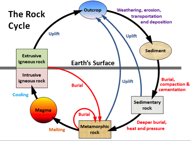
Metamorphic rocks stand as the Earth's silent narrators of geological history, meticulously recording the extreme conditions they once endured. Formed under intense pressure and high temperatures deep within the Earth's crust, these rocks undergo profound mineralogical and textural transformations without completely melting. This transformative process is frequently triggered by the ceaseless movement of tectonic plates, making metamorphic rocks a tangible, physical testament to the colossal forces that ceaselessly sculpt our planet's surface. They are, in essence, an ancient ledger, detailing the immense stresses and strains that have shaped the very foundations of our world, directly impacting future earthquake risk.
The Process of Metamorphism: Heat, Pressure, and Transformation
Metamorphism unfolds when a parent rock, known as the protolith, is exposed to vastly different physical and chemical conditions from those under which it originally formed. The intense heat required for this transformation can stem from several sources: the intrusion of molten magma into existing rock layers, or an increase in the geothermal gradient as rocks are buried deeper within the Earth. Concurrently, pressure plays an equally critical role. This pressure can be lithostatic, meaning the confining pressure exerted by the sheer weight of overlying rocks, or it can be differential, which refers to directed tectonic forces that squeeze and deform rocks from specific directions. These profound shifts in temperature and pressure can result in the growth of new minerals that are stable under the altered conditions, or they can dramatically change the rock's texture. A prime example of textural change is the development of foliation or lineation, distinctive planar or linear fabrics that clearly indicate the direction and intensity of the applied stress. Understanding these processes is fundamental to interpreting the geological history embedded within these fascinating rocks and assessing potential earthquake risk.
Key Types of Metamorphic Rocks and Their Formation in Earthquake-Prone Environments
The Earth’s crust hosts a diverse array of metamorphic rock types, each distinctively reflecting the specific conditions of its formation. These rocks are broadly categorized into two main groups: foliated and non-foliated. Non-foliated rocks, such as marble (derived from limestone) and quartzite (originating from quartz sandstone), are characterized by a lack of planar texture. Their formation is primarily driven by intense heat rather than directional pressure, often occurring during contact metamorphism where rocks are "baked" by nearby magma. In contrast, foliated rocks exhibit a layered or banded appearance, a direct consequence of intense directional pressure during their formation. Examples include slate, phyllite, schist, and gneiss, each representing progressively higher grades of metamorphism. Slate, the lowest grade, forms from shale under relatively low temperature and pressure, displaying fine, parallel cleavage. As conditions intensify, slate transforms into phyllite, then schist, characterized by larger, visible mica crystals and a wavy foliation. Gneiss, the highest grade, exhibits distinctive banding of light and dark minerals. These foliated metamorphic rocks are frequently found in compressional tectonic settings, such as folded mountain ranges and subduction zones—regions known for intense tectonic activity, where plates collide or one slides beneath another, providing the very forces that drive their transformation and the dynamic potential for earthquakes.
Metamorphic Rocks: Physical Evidence of Tectonic Plate Movement and Past Earthquake Activity
The presence and characteristics of metamorphic rock formations, particularly those displaying strong foliation or minerals indicative of high-pressure conditions, serve as direct geological indicators of past zones of active deformation. These remarkable rocks are commonly unearthed in the cores of mountain belts, colossal structures forged where tectonic plates have collided with immense force, or deep within the foundations of island arcs, which rise above active subduction zones. Their existence provides an invaluable geological 'record,' a tangible diary inscribed with details about where and how the powerful tectonic stresses responsible for ancient deformation and historical earthquakes once operated. By studying these geological archives, geologists can piece together the planet's dynamic history, understanding the distribution of immense pressures and temperatures that have continually shaped our world and continue to drive seismic activity in the present day. This deep understanding allows us to connect the Earth's ancient past with its ongoing, active processes, directly informing our approach to earthquake risk and geological prediction.
Dynamics of Tectonic Plates and Triggers of Earthquake Risk
Earthquakes are far from random occurrences; they are the inevitable outcome of energy release, meticulously accumulated over geological timescales due to the relentless movement of tectonic plates. While metamorphic rocks silently bear witness to this protracted process, symbolizing the long-term, sustained pressures, earthquakes represent the instantaneous and often dramatic manifestation of that pent-up tectonic energy, unleashed when the Earth's crust can no longer withstand the immense stress. Understanding these precise triggering mechanisms is absolutely critical for accurately assessing the potential for seismic risk in any given region. The forces that slowly transform rocks over millions of years are the very same forces that, in a sudden violent burst, can reshape landscapes in mere seconds, fundamentally influencing earthquake risk.
Subduction Zones, Faults, and Active Plate Boundaries: Hotbeds for Earthquake Risk
The vast majority of Earth’s most powerful earthquakes occur along the dynamic boundaries where tectonic plates interact. Among these, subduction zones are particularly prominent, representing regions where one oceanic plate is forced to dive beneath another continental or oceanic plate. In these colossal collision zones, the immense friction and interaction between the descending and overriding plates lead to an extraordinary accumulation of stress. When this stress finally exceeds the strength of the surrounding rocks, it is suddenly released, triggering what are known as megathrust earthquakes—some of the largest and most destructive seismic events on Earth. Beyond subduction zones, active faults, both those located within the interior of tectonic plates (intraplate faults) and those defining their edges (interplate faults), are also significant sources of earthquakes. These faults, essentially fractures in the Earth's crust where blocks of rock move past each other, frequently threaten densely populated areas, making their identification and study paramount for geohazard mitigation strategies and understanding global earthquake risk. Understanding the intricate network of these active boundaries is central to comprehending global seismic patterns and potential risks.
Energy Release Due to Accumulation of Geological Pressure
Geological pressure exerts a continuous, relentless force on the rocks situated along fault lines. As tectonic plates grind past each other, friction prevents smooth, constant motion, causing elastic strain energy to build up within the rock masses. This accumulation of stress continues until it eventually surpasses the inherent strength threshold of the rocks. At this critical point, the rocks can no longer withstand the escalating pressure; they fracture abruptly and slip past each other, releasing the stored elastic energy in the form of seismic waves. This sudden rupture and subsequent movement generate the ground shaking we perceive as an earthquake. This cyclical process of stress accumulation, sudden rupture, and subsequent release of energy is famously known as the 'elastic rebound theory,' a foundational concept in seismology that is absolutely fundamental to understanding the mechanics of how earthquakes occur. It elucidates why periods of seismic quiet are often followed by powerful, sudden movements along active fault lines, directly contributing to our understanding of earthquake risk.
The Role of Rocks in the Transmission and Amplification of Earthquake Waves
The specific types of rock through which earthquake waves travel play a pivotal and often underestimated role in how the seismic event is ultimately experienced at the Earth’s surface. Dense and rigid rocks, such as many igneous and metamorphic rocks, tend to transmit earthquake waves with high velocity and minimal attenuation. This means the waves move quickly and lose less energy, often resulting in sharp, intense, but relatively short-duration shaking. Conversely, softer, unconsolidated sedimentary layers, frequently found in basins and river valleys, can significantly amplify earthquake waves. As seismic waves transition from stiffer bedrock to these softer sediments, their velocity decreases, but their amplitude increases, leading to more prolonged and often more destructive ground shaking, even from a distant earthquake. Therefore, detailed mapping and characterization of subsurface rock types are not merely academic exercises; they are crucial components in accurate seismic hazard zoning. This geological information allows urban planners and engineers to anticipate which areas might experience the most severe shaking and to implement appropriate building codes and disaster resilience planning accordingly, mitigating earthquake risk.
Metamorphic Rocks as Indicators of Earthquake Potential: Geological Analysis
While metamorphic rocks cannot provide an instantaneous, real-time earthquake warning, their in-depth study can illuminate the historical tectonic stresses of a region and reveal the potential for current stress accumulation. They serve as natural 'archives,' meticulously preserving information about past geological forces that are profoundly relevant to the future risk of earthquakes. Reading these archives is a cornerstone of modern geophysics and geological prediction modeling.
Microstructural Studies and Mineral Composition of Metamorphic Rocks: Clues for Earthquake Risk
A detailed analysis of the microstructure within metamorphic rocks provides invaluable insights into the geological forces they have endured. Examining features such as the preferred orientation of mineral crystals, which align themselves under directional pressure, or the presence of microscopic deformation features like kink bands or undulose extinction, can reveal the precise direction and magnitude of stress experienced by the rock. Furthermore, the mineralogical composition itself is crucial; certain minerals form only under very specific pressure and temperature conditions. For instance, the presence of minerals like glaucophane (in blueschist facies) or coesite (in ultra-high pressure metamorphism) provides direct evidence of deep burial and intense tectonic compression, giving clues about the depth and conditions where active faults operated or continue to operate. This micro-scale data from metamorphic rocks is then integrated into larger models to understand and predict the macro-scale behavior of rocks within fault zones, aiding in the understanding of crustal stress and strain and refining our earthquake risk assessments.
Rock Anisotropy in Metamorphic Rocks: Inferring Fault Direction and Earthquake Risk
Metamorphic rocks frequently exhibit anisotropy, a characteristic where their physical properties, such as seismic wave velocity or electrical conductivity, vary depending on the direction of measurement. This anisotropy is often a direct result of foliation—the planar alignment of minerals—or the preferred orientation of individual mineral grains, both of which are consequences of directional pressure exerted during metamorphism. By meticulously measuring the anisotropy in these metamorphic rocks, geophysicists can infer the orientation of present-day in-situ stresses deep within the Earth's crust. This information is critical for predicting how seismic waves will propagate through the subsurface, which in turn offers significant insights into potential earthquake hazards. Understanding anisotropy allows scientists to build more accurate models of subsurface geology, aiding in the identification of active fault lines and the assessment of their potential for generating future seismic events and managing earthquake risk.
Paleoseismological Data from Metamorphic Rock Formations: Reconstructing Ancient Earthquake History
Rocks and sediments that have undergone deformation in the distant past hold invaluable records of ancient earthquakes. Paleoseismological techniques involve the meticulous excavation of trenches across active fault lines to identify and analyze layers of sediment that have been disrupted, offset, or folded by past seismic events. These disturbed layers, such as truncated strata or sand dikes, provide tangible evidence of prehistoric earthquakes. By dating these layers using radiometric methods, scientists can reconstruct a chronological history of earthquake occurrences, including their frequency and approximate magnitudes, over thousands to tens of thousands of years. This information, when combined with detailed studies of the surrounding metamorphic and other rock types, is absolutely crucial for establishing the long-term seismic history of a region. It directly feeds into probabilistic earthquake hazard assessments, informing engineers and urban planners about the recurrence intervals of large earthquakes and thus aiding in critical disaster resilience planning and the development of robust building codes, all aimed at mitigating earthquake risk based on geological prediction insights.
Challenges of Earthquake Prediction: Limits of Modern Science
Despite our rapidly advancing understanding of metamorphic rocks and the intricate dynamics of tectonic plates, predicting earthquakes with precision in terms of exact time and location remains one of the most formidable challenges in modern geophysics. The Earth operates as an exceptionally complex, non-linear system, characterized by a myriad of variables that interact in highly unpredictable ways. This inherent complexity underscores why definitive, short-term earthquake prediction continues to elude scientific breakthroughs, despite decades of intensive research and technological advancements. The planet's subsurface dynamics are far more intricate than our current models can fully capture, making precise geological prediction incredibly difficult.
The Complexity of Fault Systems and Earthquake Mechanisms
The Earth’s crust is riddled with an intricate network of fault systems, each possessing its own unique set of characteristics. These include highly variable geometries, ranging from simple planar faults to complex anastomosing networks, as well as distinct frictional properties that dictate how much force is required to induce slip. Furthermore, the specific types of rock comprising the fault zone play a crucial role, influencing everything from the fault's strength to how it ruptures. The interaction between multiple faults, where slip on one fault can trigger or inhibit activity on another, adds another layer of profound complexity. The presence and movement of subsurface fluids, such as water or magma, can also dramatically alter frictional forces, potentially facilitating or hindering fault slip. Even minuscule changes in crustal stress and strain, influenced by distant earthquakes or seasonal loading from rainfall, can have cascading effects on fault behavior. This immense variability renders the accurate modeling of fault behavior extraordinarily difficult, moving it far beyond the reach of simple, linear geological prediction models. Each fault acts as a unique, dynamic entity within a larger, interconnected and highly sensitive system, posing significant challenges to earthquake prediction.
Monitoring Technology and Its Limitations in Earthquake Prediction (GPS, Seismographs)
The advent of sophisticated monitoring technologies has undoubtedly revolutionized our capacity to observe the Earth's crustal movements and detect even minute seismic activity. Dense networks of highly sensitive seismographs continuously record ground motion, allowing scientists to pinpoint earthquake locations and magnitudes with remarkable accuracy. Continuous GPS systems provide centimeter-level measurements of surface deformation, revealing the slow, steady creep of tectonic plates and the accumulation of strain along fault lines. Advanced satellite-based techniques, such as InSAR (Interferometric Synthetic Aperture Radar), offer unprecedented spatial detail of ground uplift and subsidence. However, despite these technological marvels, the data gathered still provides an incomplete picture. A substantial portion of the critical processes that directly trigger earthquakes, particularly the precursory slip events or changes in rock properties, occur deep beneath the Earth's surface. At these extreme depths, direct measurements remain exceptionally difficult, if not entirely impossible, with current technology. Consequently, while our tools can brilliantly record the aftermath and some long-term trends, they have yet to consistently detect clear, unequivocal 'symptoms' or reliable precursors that definitively signal an impending major earthquake. This limitation represents a significant hurdle in the quest for short-term geological prediction.
Prediction Models: Probabilistic vs. Deterministic
In the realm of earthquake forecasting, it is crucial to distinguish between probabilistic and deterministic models. Currently, the vast majority of earthquake 'predictions' are inherently probabilistic. These models assess the likelihood or probability of an earthquake of a certain magnitude occurring within a specified timeframe and geographical area—for example, a 30% chance of a magnitude 7 or greater earthquake striking a particular region within the next 30 years. Such probabilistic forecasts are meticulously constructed based on a wealth of data, including extensive paleoseismological records (which reveal the history of past quakes), the measured slip rates of active faults, and sophisticated statistical analyses of historical seismicity. These models are invaluable for long-term urban planning, infrastructure design, and disaster resilience planning. In stark contrast, deterministic predictions would aim to state precisely when, where, and with what exact magnitude an earthquake will occur. Such short-term, deterministic forecasts, though highly desirable, have thus far proven consistently unattainable through scientifically robust and repeatable methods. The complex, non-linear nature of earthquake processes means that while we can understand the forces at play, pinpointing their exact moment of release remains beyond our current scientific capabilities for geological prediction.
Pro Tip: The Geological Clock
Geologists frequently utilize stable isotopes found within metamorphic rocks to precisely determine the timing and conditions of their formation. This technique, akin to a 'geological clock,' can reveal when and how these rocks were subjected to immense heat and pressure, which in turn provides crucial information about the tectonic history and potential earthquake risk of a given region. It’s an invaluable tool for understanding the deep-time processes that influence today’s seismic activity, enhancing our long-term geological prediction capabilities.
Dr. Susan Hough, a prominent seismologist, once stated, "We cannot predict earthquakes, and we probably never will be able to accurately. Our focus must be on mitigation and preparedness." This sentiment underscores a critical shift in focus from elusive prediction to realistic and effective risk management, particularly for earthquake risk.
According to the United States Geological Survey (USGS), it is estimated that over 500,000 earthquakes are detected globally each year. Of these, approximately 100,000 are strong enough to be felt by humans, and around 100 are considered major earthquakes with the potential for significant damage. Source: USGS Earthquake Hazards Program. Understanding these numbers reinforces the importance of earthquake risk mitigation strategies, rather than solely focusing on geological prediction.
Earthquake Risk Mitigation: Building Resilience Based on Geological Understanding
While the precise prediction of earthquakes continues to be an elusive goal, a profound and comprehensive understanding of geology, crucially including the study of metamorphic rocks, is absolutely indispensable for effective earthquake risk mitigation. This invaluable knowledge empowers us to proactively construct societies that are inherently more resilient to seismic hazards. By interpreting the Earth's enduring geological record, we can make informed decisions that safeguard lives and infrastructure.
The Role of Earthquake Hazard Maps and Seismic Zoning
Earthquake hazard maps are foundational tools in seismic risk mitigation, meticulously delineating areas with the highest probability of experiencing ground shaking of a specified intensity over a given period. These critical maps are constructed from a robust foundation of diverse data, including extensive historical earthquake records, detailed geological mapping of active faults, and comprehensive characterizations of subsurface rock properties. Accurate seismic zoning, derived from these hazard maps, is indispensable for urban planners and engineers. It enables them to make scientifically informed decisions regarding land use planning, ensuring that critical infrastructure and dense populations are not situated in the most vulnerable areas. Furthermore, it provides the basis for establishing and enforcing appropriate construction standards, tailored to the specific seismic risk of each zone. This proactive approach minimizes future damage and saves lives by embedding geological understanding directly into urban development strategies, a key aspect of managing earthquake risk.
Earthquake-Resistant Building Standards and Critical Infrastructure
The rigorous implementation and enforcement of strict building codes and earthquake-resistant design principles form the absolute backbone of effective earthquake mitigation strategies. Structures engineered to withstand the intense ground motions generated by seismic events can dramatically reduce both fatalities and economic losses. These advanced design methodologies often incorporate features like base isolation systems, damping mechanisms, and ductile materials that allow buildings to flex and absorb seismic energy rather than rigidly resisting it. Moreover, critical infrastructure, encompassing essential facilities such as hospitals, emergency response centers, bridges, and power generation plants, demands even more stringent design standards. Their continued functionality after a major earthquake is paramount for disaster recovery and maintaining societal order. Investing in and adhering to these high standards is not merely a regulatory burden; it is a fundamental societal investment in safety, resilience, and rapid recovery following seismic events, directly addressing earthquake risk.
Community Preparedness and Early Warning Systems
Beyond structural resilience, comprehensive public education campaigns on how to act safely before, during, and immediately after an earthquake are incredibly vital for community preparedness. Empowering individuals with knowledge—such as "Drop, Cover, and Hold On"—can significantly reduce injuries and panic. Complementing these educational efforts, the development and deployment of Earthquake Early Warning (EEW) systems represent a significant leap in mitigation capabilities. These sophisticated systems function by rapidly detecting the faster-traveling, less destructive P-waves immediately after an earthquake initiates. They then transmit alerts ahead of the arrival of the slower, but far more damaging S-waves and surface waves. While not a prediction in the traditional sense, EEW systems can provide precious seconds to minutes of warning, allowing people to take protective actions, automated systems to shut down machinery, and emergency services to prepare. This brief window of time can save countless lives and significantly reduce infrastructure damage, proving itself an invaluable mitigation step in highly seismic regions against earthquake risk.
The Philippine Sea Plate: Metamorphic Rocks and Present-Day Earthquake Risk
In the vibrant and seismically active region of Southeast Asia, particularly along the dynamic boundaries of the Philippine Sea Plate, we encounter a compelling, real-world illustration of how profound, deep-seated geology directly influences earthquake risk. This restless oceanic plate is in constant motion, relentlessly colliding and interacting with surrounding tectonic plates. These interactions give rise to a spectacular arc of islands that are intensely active both volcanically and seismically. Deep within these active collision zones, ancient sedimentary and igneous rocks are subjected to immense pressures and temperatures, undergoing transformative metamorphism to become high-pressure metamorphic rocks such as blueschists and eclogites. The very presence of these specific, high-pressure metamorphic rocks is powerful evidence, indicating that in geological eons past, this region experienced extraordinary tectonic forces—forces that are precisely analogous to those currently driving the powerful earthquakes that regularly strike the Philippines, Taiwan, and their surrounding areas. Detailed scientific studies of these remarkable rocks allow geoscientists to unravel the complex history of deformation, mapping out the active fault zones that are the sources of today's formidable earthquakes. This geological insight provides absolutely crucial understanding for effective risk management in what is unequivocally one of the most seismically active and geologically complex regions on Earth, underscoring the deep connection between Earth's ancient history and its present-day hazards, and guiding future geological prediction efforts.
| Type of Metamorphic Rock | Key Characteristics | Implications for Earthquake Risk |
|---|---|---|
| Schist | Strong foliation, rich in mica/chlorite minerals, formed under medium pressure & temperature. | Indicates a history of significant deformation. Foliation planes can act as planes of weakness, potentially reactivating under earthquake-induced stress, increasing local earthquake risk. |
| Gneiss | Distinct banding (alternating light & dark mineral layers), formed under high pressure & temperature. | Signifies intense tectonic history. High degrees of deformation can be associated with deep-seated fault zones, contributing to regional earthquake risk. |
| Marble/Quartzite | Non-foliated, interlocking crystals, formed primarily by heat. | Tends to be more structurally stable, but their formation location (e.g., in collision zones) remains relevant for overall seismic risk analysis and understanding earthquake potential. |
| Mylonite | Highly deformed, fine-grained, formed in fault shear zones. | Direct indicator of active or ancient faulting. Brittle mylonitic material can become a zone of earthquake initiation, directly impacting local earthquake risk. |
Key Takeaways
- Metamorphic rocks serve as geological 'archives,' meticulously recording a history of extreme pressure and temperature conditions resulting from tectonic plate movements, providing invaluable insights into regional earthquake risk.
- The unique characteristics of metamorphic rocks (microstructure, mineral composition, anisotropy) provide crucial clues about the forces shaping the Earth's crust and the location of active fault zones, aiding in long-term geological prediction.
- While incapable of deterministically predicting earthquakes, the study of metamorphic rocks is indispensable for paleoseismology and comprehensive long-term earthquake risk assessment.
- The primary challenges in earthquake prediction stem from the inherent complexity of fault systems and the current limitations of monitoring technology.
- Earthquake risk mitigation primarily focuses on building resilience through accurate seismic zoning, stringent building standards, and robust community preparedness, all underpinned by a comprehensive geological understanding.
Frequently Asked Questions
What are metamorphic rocks and how are they related to earthquakes?
Metamorphic rocks are rocks that have been fundamentally transformed by extreme heat and pressure deep within the Earth's crust. Their intrinsic connection to earthquakes lies in their formation environments: these rocks frequently form in regions of intense tectonic activity, such as plate boundaries and subduction zones, which are precisely where the vast majority of earthquakes also occur. They stand as tangible physical evidence of the immense forces that both create earthquakes and reshape the Earth's crust, making them crucial for understanding earthquake risk.
Can we use metamorphic rocks to predict when an earthquake will happen?
Not directly for short-term prediction. While metamorphic rocks offer profound insights into a region's geological history and past stress conditions—making them incredibly useful for long-term earthquake risk assessment and identifying earthquake-prone zones—they do not provide immediate, specific indicators for the time, location, or magnitude of an impending earthquake. Their value is in understanding the long-term context of seismic activity and informing geological prediction models, not in real-time forecasting.
How does geological science contribute to earthquake risk mitigation?
Geological science makes indispensable contributions to earthquake risk mitigation through several critical avenues. These include the precise mapping of active fault lines, identifying subsurface rock types (including metamorphic rocks) that can amplify earthquake ground motion, conducting paleoseismological studies to understand past earthquake cycles, and developing comprehensive earthquake hazard maps and seismic zoning regulations. This geological information is absolutely crucial for informed urban planning, the design of earthquake-resistant buildings, and effective emergency preparedness strategies, all aiming to reduce earthquake risk.
What is the difference between probabilistic and deterministic earthquake prediction?
Probabilistic earthquake prediction provides an assessment of the likelihood that an earthquake of a certain magnitude will occur within a specific timeframe and geographic area (e.g., "a 30% chance of a M7+ earthquake in the next 50 years"). This is based on historical data and geological understanding. Deterministic prediction, which remains scientifically unachievable, would state with high accuracy exactly when, where, and how large an earthquake will be. Current geological prediction capabilities are limited to probabilistic assessments for earthquake risk.
Conclusion: Listening to Earth's Enduring Messages for a Resilient Future
The journey to comprehend the intricate relationship between metamorphic rocks and earthquake risk is a compelling narrative, chronicling the Earth's extraordinary power and humanity's relentless pursuit to unravel its deepest secrets. Metamorphic rocks, with their indelible imprints of immense pressure and profound transformation, offer an invaluable window into a geological past that has fundamentally shaped our current landscapes and inherent hazards. While precise earthquake prediction remains an enduring aspiration, the profound knowledge we glean from these ancient rocks and other geological disciplines is the undeniable cornerstone for assessing earthquake risk and constructing societies that are inherently smarter, more resilient, and ultimately safer. By persistently investing in scientific research, advancing monitoring technologies, and fostering widespread public education, we can collectively learn to 'listen' more attentively to the enduring messages inscribed within the Earth's layers. This deep understanding empowers us to harness geological insights, not for a fleeting forecast, but for a profound, lasting impact on the protection of lives and the secure future of our civilizations, guided by a sophisticated approach to geological prediction and mitigation.
